9-25-10
I had plans for
an overnighter but when that fell through I joined Gary and John for a
trip to Mt. David. I first hiked Mt. David in 2001. The next
year I convinced Gary to join me. In 2004
we took a more interesting way back via the meadow below the ridge
trail. In 2008
we made one more visit. This year with John along we chose to repeat
our off trail jaunt of 2004. David is a long day with much distance and
elevation to cover. On a sunny day in late September it can provide
some spectacular color too. That is a prime reason I keep returning.
Since the driving plus hiking time is considerable we chose to meet at the 160th park and ride off I-405 at 5:15 am. That meant a 4:00 am wake up time. The drive was in the dark for another hour. Traffic was light as we cruised over Stevens Pass and on to Lake Wenatchee. On previous visits we saw one or two groups for the day. This time it was different. The parking lot at the end of the White River Road was packed. A number of big horse trailers and at least half a dozen cars. One hiker left for David as we arrived and several more groups were getting ready to go. I guess this hike has been discovered.
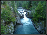
We were on the trail at 7:22 am. It was in the high 30s and we started off at a fast pace. Since the trail drops 160' in the first mile we needed to go pretty fast to generate any body heat. When the climbing begins it doesn't let up for the next 3 1/2 miles which gains about 3200'. The climbing is much easier than the numbers would suggest. The trail climbs steadily in many switchbacks with few steep spots. There are almost no steps or roots.
It did not take long to warm up once the uphill commenced. We were down to shorts and short sleeves by then. The climb is in forest with a few views out. The valley below was under a low fog while we had only sunshine above. The bright white fog sat in the valley bottom all the way back to Lake Wenatchee. We reached the ridge top in 1:57 at 9:19. 3200' gained in under two hours but still 2700' more to go for the day. Since we did not catch up with the hiker who left as we arrived we figured at his pace he would be coming down while we were still ascending. That proved to be correct.
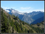
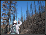
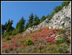
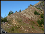
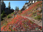
Now that the grunt work was done the fun part began. The ridge walk is one of the best in the Cascades. To the right, to the left, and even right along the crest in places. A short ways along the ridge we reached the spot of a recent fire. We knew there had been a fire. I had hoped it would be lower down and not on the ridge top. One tree requires climbing under it. Otherwise the going is not difficult. The fire did burn up all underbrush and I fear that the bare dirt on a steep slope may lead to a muddy slick mess next year. Some work to widen and flatten the narrow tread would be much appreciated.
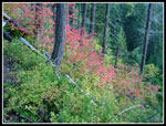
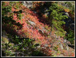
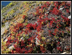
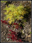
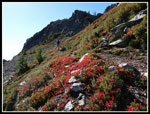
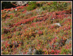
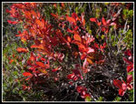
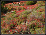
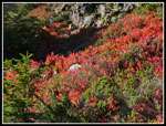
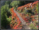
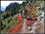
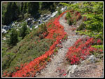
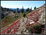
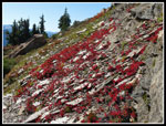
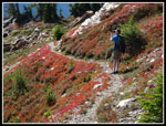
After the burn the leaf show began. When the sky is clear the sun backlights the leaves bright shades of red and orange. We expected this part would be very slow with many photos taken. We were not disappointed. The last several visits have been on clear sunny days near the peak of the colors and this time might have been the best of all. Our progress was very slow. One group blew by as we were taking yet more photos. They were soon out of sight.
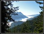
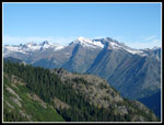
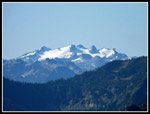
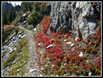
We heard many pikas and a few marmots as the rock fields provide perfect conditions for them. The early morning sun and no haze gave us great views north to Clark Mountain and south to Hinman, Daniel, and Mt. Rainier. After switchbacking up the steep gully to the ridge top we stopped for a food and water break. We had taken nearly two hours to reach this spot from where we first reached the ridge top. Really slow going. Now we dropped down the climbed back to the ridge just below the summit. As usual we lost the route in the loose rocks and followed cairns up to where the narrow walkway was blasted out of rock and leads to the top.
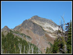
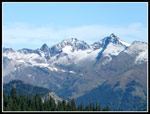
It was just after noon when we arrived. The early solo hiker had passed us coming down and we shared the top with the one group that passed us on the ridge. My GPS showed 7.38 miles with 5400' gained to the top. At the top all the peaks to the north came into view. They had a light white coat of fresh snow. Glacier Peak looked very white. Sloan, Three Fingers, Whitehorse, Pugh, Whitechuck, Indian Head, Saul, Whittier, Maude, Seven Fingered Jack, and more were laid out around us. Other than Glacier Peak not much blocks the view from the 7420' summit of David.
We directed the other group over to the stone outhouse and sat down to enjoy a well deserved lunch. There was only a light wind when we arrived but at that elevation a jacket was needed even with the bright sunshine. We spent a full hour on top including another visit to the stone igloo. We could see below that a larger group was nearing the top. The other group wanted to descend but could not go down while there were people on the last narrow ledge to the top. Not quite like the Hillary Step but a real bottleneck ensued. It took a good five minutes before a gap opened that allowed them to descend.
After four visits where we saw no more than a few groups all day it was strange to see about 15 people either on the summit or trying to get off of it. One person in the arriving groups mentioned seeing 20 names on the trailhead sign up for Mt. David this day. It turns out the dozen arriving hikers were in a number of different groups that all just happened to summit at the same time. David's friend Lauren was in the last group. I did not expect to see anyone I knew on this trail.
When everyone was up we were able to head down. Towards the end of our stay the wind really began to blow and I was not too unhappy to leave the icy summit. We quickly dropped back to the ridge and dropped off the north side where the wind was blocked. Off came the jackets and it was summer once again. We switchbacked down the talus slope to the low point and left the trail. Instead of climbing back to the ridge top we dropped straight down the steep rock and heather slope. The first part seemed tougher than on our 2004 trip. After a few route finding discussions we managed to drop down to gentler terrain.
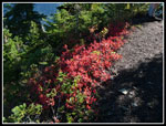
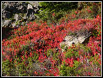
It was slow going on the boulders and talus as we worked out way down towards the meadow far below. There was still some snow on the north facing slope though none on our route. The melting fed creeks under the rocks. In places there was boggy ground to work around. Eventually we dropped below the rocks and onto dirt and grass with some trees and berry bushes. The leaves here were ablaze with color. Much more time was spent with cameras out. Some navigation is necessary on the descent as there are steep cliffs in places. We descended between creek gorges. I noticed unnatural colors down in a creek meadow below us and we dropped down to explore. Someone had cached tarps and metal boxes full of food and toiletry/camp items. That was a strange place to find those items. We also found a fire pit nearby.
We continued down and soon reached the meadow below. The creeks falling from above form a meandering creek in the meadow. At the far end is a marshy tarn. We knew that the far side of the tarn is where we would pick up a trail that climbs back to the main trail on the ridge crest. Lots of colors in the meadow. Red leaves and yellow grasses cover the meadow floor. Once around he tarn Gary pointed out the fantastic reflections. We could see the summit of David in the tarn. It was perfectly calm providing a near perfect reflection. Out came the cameras again.
Satisfied that we had seen all there was to see we headed up the trail. We had been able to see hikers descending along the ridge while we did our off trail hike. We expected that we were now the last people on the trail. The climb up from the meadow is not steep but it did gain 400', more than we expected. Back on the ridge we had 3400' of downhill and 160' of uphill to look forward to. We took one last break at the point the ridge is first reached.
The downhill went fast. It took us 1:36 to descend then gently climb the 4 1/2 miles back to the car. Only a few cars remained at 5:48 when we made it down about 10 1/2 hours after starting our hike. The GPS showed our detour to be about 1/8th of a mile shorter than the ridge route. Shorter but not faster. I had 14.62 miles round trip. We headed over to the 59er Diner for dinner and then the long drive. I arrived home at 9:30 pm. It was a very long and very enjoyable day. A lot of climbing, a great summit, a fun off trail section, and some of the best color of the year. More crowded than I would have believed but a great day in the mountains nonetheless.
Click on thumbnails to get larger pictures.
Photo Page 2
Trips - 2010
Home
Since the driving plus hiking time is considerable we chose to meet at the 160th park and ride off I-405 at 5:15 am. That meant a 4:00 am wake up time. The drive was in the dark for another hour. Traffic was light as we cruised over Stevens Pass and on to Lake Wenatchee. On previous visits we saw one or two groups for the day. This time it was different. The parking lot at the end of the White River Road was packed. A number of big horse trailers and at least half a dozen cars. One hiker left for David as we arrived and several more groups were getting ready to go. I guess this hike has been discovered.
We were on the trail at 7:22 am. It was in the high 30s and we started off at a fast pace. Since the trail drops 160' in the first mile we needed to go pretty fast to generate any body heat. When the climbing begins it doesn't let up for the next 3 1/2 miles which gains about 3200'. The climbing is much easier than the numbers would suggest. The trail climbs steadily in many switchbacks with few steep spots. There are almost no steps or roots.
It did not take long to warm up once the uphill commenced. We were down to shorts and short sleeves by then. The climb is in forest with a few views out. The valley below was under a low fog while we had only sunshine above. The bright white fog sat in the valley bottom all the way back to Lake Wenatchee. We reached the ridge top in 1:57 at 9:19. 3200' gained in under two hours but still 2700' more to go for the day. Since we did not catch up with the hiker who left as we arrived we figured at his pace he would be coming down while we were still ascending. That proved to be correct.
Now that the grunt work was done the fun part began. The ridge walk is one of the best in the Cascades. To the right, to the left, and even right along the crest in places. A short ways along the ridge we reached the spot of a recent fire. We knew there had been a fire. I had hoped it would be lower down and not on the ridge top. One tree requires climbing under it. Otherwise the going is not difficult. The fire did burn up all underbrush and I fear that the bare dirt on a steep slope may lead to a muddy slick mess next year. Some work to widen and flatten the narrow tread would be much appreciated.
After the burn the leaf show began. When the sky is clear the sun backlights the leaves bright shades of red and orange. We expected this part would be very slow with many photos taken. We were not disappointed. The last several visits have been on clear sunny days near the peak of the colors and this time might have been the best of all. Our progress was very slow. One group blew by as we were taking yet more photos. They were soon out of sight.
We heard many pikas and a few marmots as the rock fields provide perfect conditions for them. The early morning sun and no haze gave us great views north to Clark Mountain and south to Hinman, Daniel, and Mt. Rainier. After switchbacking up the steep gully to the ridge top we stopped for a food and water break. We had taken nearly two hours to reach this spot from where we first reached the ridge top. Really slow going. Now we dropped down the climbed back to the ridge just below the summit. As usual we lost the route in the loose rocks and followed cairns up to where the narrow walkway was blasted out of rock and leads to the top.
It was just after noon when we arrived. The early solo hiker had passed us coming down and we shared the top with the one group that passed us on the ridge. My GPS showed 7.38 miles with 5400' gained to the top. At the top all the peaks to the north came into view. They had a light white coat of fresh snow. Glacier Peak looked very white. Sloan, Three Fingers, Whitehorse, Pugh, Whitechuck, Indian Head, Saul, Whittier, Maude, Seven Fingered Jack, and more were laid out around us. Other than Glacier Peak not much blocks the view from the 7420' summit of David.
We directed the other group over to the stone outhouse and sat down to enjoy a well deserved lunch. There was only a light wind when we arrived but at that elevation a jacket was needed even with the bright sunshine. We spent a full hour on top including another visit to the stone igloo. We could see below that a larger group was nearing the top. The other group wanted to descend but could not go down while there were people on the last narrow ledge to the top. Not quite like the Hillary Step but a real bottleneck ensued. It took a good five minutes before a gap opened that allowed them to descend.
After four visits where we saw no more than a few groups all day it was strange to see about 15 people either on the summit or trying to get off of it. One person in the arriving groups mentioned seeing 20 names on the trailhead sign up for Mt. David this day. It turns out the dozen arriving hikers were in a number of different groups that all just happened to summit at the same time. David's friend Lauren was in the last group. I did not expect to see anyone I knew on this trail.
When everyone was up we were able to head down. Towards the end of our stay the wind really began to blow and I was not too unhappy to leave the icy summit. We quickly dropped back to the ridge and dropped off the north side where the wind was blocked. Off came the jackets and it was summer once again. We switchbacked down the talus slope to the low point and left the trail. Instead of climbing back to the ridge top we dropped straight down the steep rock and heather slope. The first part seemed tougher than on our 2004 trip. After a few route finding discussions we managed to drop down to gentler terrain.
It was slow going on the boulders and talus as we worked out way down towards the meadow far below. There was still some snow on the north facing slope though none on our route. The melting fed creeks under the rocks. In places there was boggy ground to work around. Eventually we dropped below the rocks and onto dirt and grass with some trees and berry bushes. The leaves here were ablaze with color. Much more time was spent with cameras out. Some navigation is necessary on the descent as there are steep cliffs in places. We descended between creek gorges. I noticed unnatural colors down in a creek meadow below us and we dropped down to explore. Someone had cached tarps and metal boxes full of food and toiletry/camp items. That was a strange place to find those items. We also found a fire pit nearby.
We continued down and soon reached the meadow below. The creeks falling from above form a meandering creek in the meadow. At the far end is a marshy tarn. We knew that the far side of the tarn is where we would pick up a trail that climbs back to the main trail on the ridge crest. Lots of colors in the meadow. Red leaves and yellow grasses cover the meadow floor. Once around he tarn Gary pointed out the fantastic reflections. We could see the summit of David in the tarn. It was perfectly calm providing a near perfect reflection. Out came the cameras again.
Satisfied that we had seen all there was to see we headed up the trail. We had been able to see hikers descending along the ridge while we did our off trail hike. We expected that we were now the last people on the trail. The climb up from the meadow is not steep but it did gain 400', more than we expected. Back on the ridge we had 3400' of downhill and 160' of uphill to look forward to. We took one last break at the point the ridge is first reached.
The downhill went fast. It took us 1:36 to descend then gently climb the 4 1/2 miles back to the car. Only a few cars remained at 5:48 when we made it down about 10 1/2 hours after starting our hike. The GPS showed our detour to be about 1/8th of a mile shorter than the ridge route. Shorter but not faster. I had 14.62 miles round trip. We headed over to the 59er Diner for dinner and then the long drive. I arrived home at 9:30 pm. It was a very long and very enjoyable day. A lot of climbing, a great summit, a fun off trail section, and some of the best color of the year. More crowded than I would have believed but a great day in the mountains nonetheless.
 White River |
 First Good Color |
 Fog In The Valley |
 First Bright Red |
 Partial Clark Mountain |
 Hiking Through Burn |
 Red Slope |
 Fiery Red |
 Contrasting Colors |
 Mt. David |
 Clark Mountain |
 Fresh Snow On Peaks |
 Mt. Daniel |
 Gary Ahead |
 Red Up To Rock |
 A Sea Of Red |
 Bright Red Leaves |
 Our Pace Slows |
 Best Color In Years |
 Sun Is Behind Us |
 Red Border |
 Red & Granite |
 John & Gary |
 Red Edge |
 Fantastic |
 Other Hikers |
 Ridge Top Red |
 Shiny Leaves & Rocks |
 Gary At Work |
 Red, Green, & White |
Photo Page 2
Trips - 2010
Home