9/06-08/10
After three
straight years of having company for my Idaho backpacking trip I found
myself going solo this year. I drove over on the Saturday of Labor Day
weekend. On Sunday I did a hike up Bald Mountain
to 9150' to help get adjusted to the elevation. The forecast was
turning negative and I struggled to figure out where I wanted to go and
for how long. I brought light summer gear and winter gear. I expected
anything from 70 degree days to snow and mid 20 degree nights. At the
last minute I chose to head out on Monday and take a four season tent
but a 30 degree summer sleeping bag.
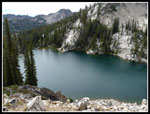
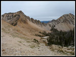
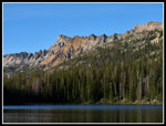
My final choice was to front load the mileage and then day hike an area I had first see last year. Gary and I had hiked to a ridge top lake between Vernon and Ardeth Lakes in the Sawtooths. Gary had mentioned scrambling up Glens Peak years before. We scrambled up the ridge behind the ridge top lake and looked over to Glens Peak and down to Ten Lakes Basin. A string of jewels they were. Small and larger lakes set in a bowl of granite. Glens Peak and those lakes became my destination.
Day 1
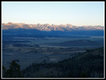
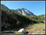
I set out at 6:30 am for the drive north to Pettit Lake. It is only 48 miles from my brothers house to the trailhead. It was Labor Day morning and there was no traffic. I cruised over Galena Summit at 8701' and descended into the Salmon River Valley. I stopped at the overlook to get a few shots of the morning sun shining on the Sawtooth and White Cloud Mountains. Soon I was down to the gravel road and onto the Pettit Lake trailhead. There were a dozen cars in the lot. Not too bad for a holiday weekend.
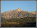
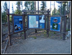
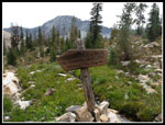
It was chilly but not too cold as I started up the trail at 7:45. What looked like steam wafted over the lake creating an eerie effect. McDonald Mountain looms high over the 7000' lake. I have hiked up the trail to Alice and Toxaway Lake two times before. This time I turned off after 1/4 mile on the route over to the Yellow Belly Trail. The two trails form a loop. My trail climbed 500' to a ridge then descended 400' to the Yellow Belly Trail at 2.1 miles. A short way up that trail is the Sawtooth Wilderness sign in box.
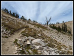
The trail is very gently graded as it ascends the valley. The creek is far away at first. All the trails I hiked on this trip are open to horses and dusty as a result. Less of a problem with just me kicking up dust and nobody behind me to breath it. The forest is mostly open with minimal underbrush. The route angles over to the creek and crosses. There is a narrow log across that I could never have made it across without two poles. With them I tight roped across with dry feet.
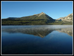
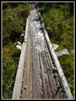
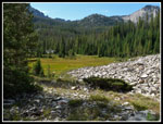
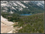
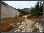
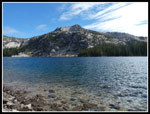
The route has a few slightly steep short climbs but is mostly gentle all the way. A few loud cascades can be heard and in a few places seen. Several large meadows are crossed that must be full of wildflowers earlier in the year. Fall colors are beginning as well. Farley Lake is the next landmark. It is a good sized lake set below steep rock walls of the mountain on the other side of the valley. I met a group coming out here who noted how cold the night before had been. Apparently it was in the mid 20s with a dusting of snow. I crossed a wooden boardwalk along Farley that still had ice on it.
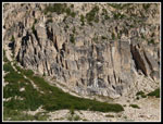
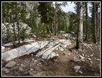
At the 6 2/3 mile point I reached the junction with the trail to Edith Lake. This was where I was headed next. Most folks continue up the Yellow Belly Trail to Toxaway Lake. I did not expect to see many on this steeper trail. The route winds it's way up the valley to Edith Lake crossing the outlet creek twice before the lake. Both crossings are just below waterfalls over granite slabs. The whole area is full of granite. The higher you go the better it gets.
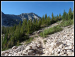
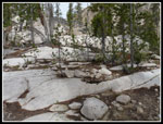
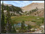
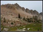
Edith Lake at 8660' sits with sheer granite on one side and a lower granite cliff on another. There are flat spots for camping. A number of areas near the lake shore have signs asking campers to avoid these places and allow the land to heal from over use. That is the only place I have seen these in the Sawtooths. The trail climbs through a talus field to views of the lake from the top of the low cliffs. It meanders up the valley alongside numerous talus fields. I heard and saw dozens of pikas working hard for the coming winter.
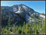
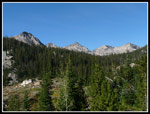
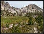
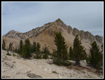
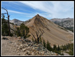
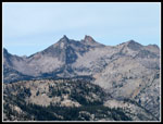
A few nearly dry creeks were lined with wildflowers in this dry environment. The trail soon reaches another junction at a small tarn. This is where Gary and I came through the year before from Imogene Lake. Now back on familiar trail I began to get some views out. This next section of trail up to the ridge top is definitely a rebuild job. The trail now ascends with impossibly long and gentle switchbacks. It takes one mile to climb 400'. The trees are fewer and smaller above 9000' but they do not disappear. In the Washington Cascades I would have been 2000' above the last trees. Views out to the White Cloud Mountains open up. White David O. Lee Peak and huge Castle Peak are easy to pick out.
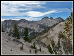
As I neared the ridge top at 9400' the wind picked up. Nice and cool at first it soon became a little too cold. I crested the ridge and had a short 150' descent to Toxaway Divide (Sand Mountain Pass). Here I stopped for a lunch break. A group of backpackers was already there. We had a nice conversation while eating. They confirmed the cold night before and the good fishing in Vernon Lake. Too bad I had no rod as everyone wanted to talk about fishing.
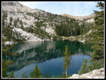
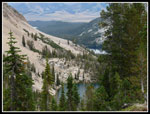
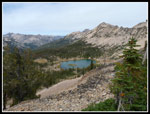
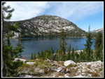
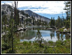
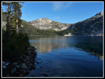
We said our goodbyes and I commenced my 2 1/2 mile descent to Edna Lake. This section I had hiked three times before. It is a familiar stretch now. Switchbacks gave way to meadows and then forest. I met two more backpackers. They were also from Washington. At the junction near Edna I took the left fork to Vernon, Ardeth, and Spangle Lakes. Vernon is just a short 1/4 mile beyond Edna. All of these lakes are a good size. At Vernon I had my last climb of the day. 400' up to the saddle. There I reached the small lake where Gary and I had camped. It was tempting to stay there and day hike down to Ardeth but I chose to go on.
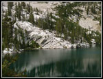
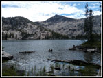
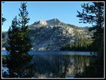
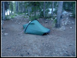
I dropped 600' to Ardeth. Once across the outlet there are a number of campsites. I chose one near the junction with a trail down to Elk Lake. No competition as I was the only person at the lake. It would be 24 hours before I saw another soul. It was only 3:00 as I set up camp. I brought my Hilleberg Akto. I think it was the first time I have used it not on snow. I was prepared for sub freezing cold and possible high winds. Later I walked down to the end of the lake where there are a number of big horse campsites. They were not in good shape as horse droppings, mud, and soot from many campfires dotted each camp.
Knowing it would be a long night I stayed out until just before dark at 8:15 pm. My thermometer already read 45 degrees. It was cooling rapidly. I was glad not to have brought the tarptent. I read 38 degrees in the tent but it was a little below freezing outside. I slept just fine in my 30 degree bag.
Click on thumbnails to get larger pictures.
Photo Page 2
Trips - 2010
Home
My final choice was to front load the mileage and then day hike an area I had first see last year. Gary and I had hiked to a ridge top lake between Vernon and Ardeth Lakes in the Sawtooths. Gary had mentioned scrambling up Glens Peak years before. We scrambled up the ridge behind the ridge top lake and looked over to Glens Peak and down to Ten Lakes Basin. A string of jewels they were. Small and larger lakes set in a bowl of granite. Glens Peak and those lakes became my destination.
Day 1
I set out at 6:30 am for the drive north to Pettit Lake. It is only 48 miles from my brothers house to the trailhead. It was Labor Day morning and there was no traffic. I cruised over Galena Summit at 8701' and descended into the Salmon River Valley. I stopped at the overlook to get a few shots of the morning sun shining on the Sawtooth and White Cloud Mountains. Soon I was down to the gravel road and onto the Pettit Lake trailhead. There were a dozen cars in the lot. Not too bad for a holiday weekend.
It was chilly but not too cold as I started up the trail at 7:45. What looked like steam wafted over the lake creating an eerie effect. McDonald Mountain looms high over the 7000' lake. I have hiked up the trail to Alice and Toxaway Lake two times before. This time I turned off after 1/4 mile on the route over to the Yellow Belly Trail. The two trails form a loop. My trail climbed 500' to a ridge then descended 400' to the Yellow Belly Trail at 2.1 miles. A short way up that trail is the Sawtooth Wilderness sign in box.
The trail is very gently graded as it ascends the valley. The creek is far away at first. All the trails I hiked on this trip are open to horses and dusty as a result. Less of a problem with just me kicking up dust and nobody behind me to breath it. The forest is mostly open with minimal underbrush. The route angles over to the creek and crosses. There is a narrow log across that I could never have made it across without two poles. With them I tight roped across with dry feet.
The route has a few slightly steep short climbs but is mostly gentle all the way. A few loud cascades can be heard and in a few places seen. Several large meadows are crossed that must be full of wildflowers earlier in the year. Fall colors are beginning as well. Farley Lake is the next landmark. It is a good sized lake set below steep rock walls of the mountain on the other side of the valley. I met a group coming out here who noted how cold the night before had been. Apparently it was in the mid 20s with a dusting of snow. I crossed a wooden boardwalk along Farley that still had ice on it.
At the 6 2/3 mile point I reached the junction with the trail to Edith Lake. This was where I was headed next. Most folks continue up the Yellow Belly Trail to Toxaway Lake. I did not expect to see many on this steeper trail. The route winds it's way up the valley to Edith Lake crossing the outlet creek twice before the lake. Both crossings are just below waterfalls over granite slabs. The whole area is full of granite. The higher you go the better it gets.
Edith Lake at 8660' sits with sheer granite on one side and a lower granite cliff on another. There are flat spots for camping. A number of areas near the lake shore have signs asking campers to avoid these places and allow the land to heal from over use. That is the only place I have seen these in the Sawtooths. The trail climbs through a talus field to views of the lake from the top of the low cliffs. It meanders up the valley alongside numerous talus fields. I heard and saw dozens of pikas working hard for the coming winter.
A few nearly dry creeks were lined with wildflowers in this dry environment. The trail soon reaches another junction at a small tarn. This is where Gary and I came through the year before from Imogene Lake. Now back on familiar trail I began to get some views out. This next section of trail up to the ridge top is definitely a rebuild job. The trail now ascends with impossibly long and gentle switchbacks. It takes one mile to climb 400'. The trees are fewer and smaller above 9000' but they do not disappear. In the Washington Cascades I would have been 2000' above the last trees. Views out to the White Cloud Mountains open up. White David O. Lee Peak and huge Castle Peak are easy to pick out.
As I neared the ridge top at 9400' the wind picked up. Nice and cool at first it soon became a little too cold. I crested the ridge and had a short 150' descent to Toxaway Divide (Sand Mountain Pass). Here I stopped for a lunch break. A group of backpackers was already there. We had a nice conversation while eating. They confirmed the cold night before and the good fishing in Vernon Lake. Too bad I had no rod as everyone wanted to talk about fishing.
We said our goodbyes and I commenced my 2 1/2 mile descent to Edna Lake. This section I had hiked three times before. It is a familiar stretch now. Switchbacks gave way to meadows and then forest. I met two more backpackers. They were also from Washington. At the junction near Edna I took the left fork to Vernon, Ardeth, and Spangle Lakes. Vernon is just a short 1/4 mile beyond Edna. All of these lakes are a good size. At Vernon I had my last climb of the day. 400' up to the saddle. There I reached the small lake where Gary and I had camped. It was tempting to stay there and day hike down to Ardeth but I chose to go on.
I dropped 600' to Ardeth. Once across the outlet there are a number of campsites. I chose one near the junction with a trail down to Elk Lake. No competition as I was the only person at the lake. It would be 24 hours before I saw another soul. It was only 3:00 as I set up camp. I brought my Hilleberg Akto. I think it was the first time I have used it not on snow. I was prepared for sub freezing cold and possible high winds. Later I walked down to the end of the lake where there are a number of big horse campsites. They were not in good shape as horse droppings, mud, and soot from many campfires dotted each camp.
Knowing it would be a long night I stayed out until just before dark at 8:15 pm. My thermometer already read 45 degrees. It was cooling rapidly. I was glad not to have brought the tarptent. I read 38 degrees in the tent but it was a little below freezing outside. I slept just fine in my 30 degree bag.
 Morning Sun On Sawtooths |
 A Sawtooth Peak |
 Tin Cup Trailhead |
 McDonald Peak |
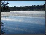 Smoke On The Water |
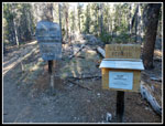 Wilderness Register |
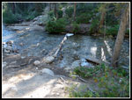 Creek Crossing |
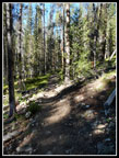 Yellow Belly Trail |
 Meadow & Views |
 Granite Wall |
 More Granite |
 Crossing Talus |
 Farley Lake |
 More Peaks Appear |
 Ice On Boardwalk |
 Talus & Meadow |
 Granite Slabs |
 Trail Over Rock |
 Edith Lake |
 Slab Into Edith Lake |
 Edith Below |
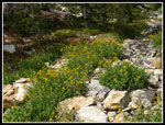 Flowers Still Blooming |
 Trail Junction |
 Tarn In Meadow |
 9000' Meadow |
 Red Rocks |
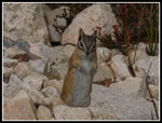 What's For Dinner? |
 Farley & Edith |
 Peak Near Toxaway Lake |
 Red & White |
 Nearing 9400' Pass |
 Interesting Colors |
 Imogene Saddle |
 Sand Mountain |
 Lake Near Trail |
 Edna Lake |
 Sharp Spires |
 Snowyside Peak |
 Fall Color |
 Edith Lake |
 Vernon Lake |
 Lake 8860' |
 Ardeth Lake Below |
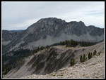
 Glens Peak |
 Ardeth Lake View |
 Ten Lakes Below Glens |
 Ridge Above Ardeth |
 Hillberg Akto |
Photo Page 2
Trips - 2010
Home