Page 2
Day 2
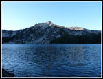
I woke up at 6:45 and pulled myself out of my warm sleeping bag at 7:15. Today would be the payoff for the long 14 miles the day before. It was cold but the sun was peeking out. This was to be the warmest day of the week. Not a cloud in the sky. By 8:25 I had my gear packed away in my Osprey Aether 70 "day pack" A little overkill for day hiking but at least it was a lot lighter than the day before. From this point on I had a map, a GPS, and Gary's instructions to guide me. He said "hike to the pass between Ardeth and Spangle Lakes and follow the ridge to the top of Gleans Peak.
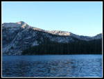
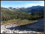
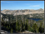
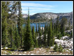
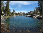
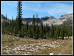
Ten Lakes Basin sits on a wide bench 600' above Ardeth and 1200' below Glens. The drop to Ardeth is a sheer granite cliff. From Ardeth below it is not clear that any bench exists. From the ridge above camp the year before we had an up close look at all the lakes and all the granite. The bench drops down to another bench above my camp. More of the ten lakes are here in forest.
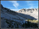
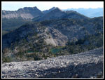
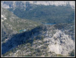
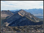
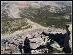
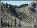
My plan was to summit Glens (or at least try), drop back to the saddle, then descend and climb again to the majority of Ten Lakes Basin. First I wanted to get the 1825' climb from Ardeth at 8,228' to Glens Peak at 10,053 out of the way while it was cool and no afternoon haze formed. The trail from the lake ascends gently in forest then meadows and finally switchbacks up the bare slope to Spangle Saddle at about 8900'. Here I had my first look at the ridge and summit of Glens Peak. The ridge had looked pretty mellow from camp. Now it looked to be about 60 degrees near the top. Only Gary's talk about the enjoyable scramble gave me any hope of a solo summit. I'm much more conservative when alone.
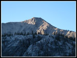
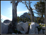
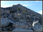
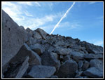
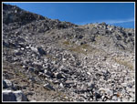
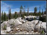
I meandered up the wide ridge in forest and granite boulders. Easy going at first. After 600' of climbing I was left with the looming summit block and 600' to go. Now it still looked very tough but maybe possible. That last 600' is all on boulders and talus. I don't think there is a piece of solid rock on the mountain. Fortunately most of the boulders are solidly in place. In places I found bits of a climbers path but the loose sand was slicker than staying on boulders.
The steepest part was just below the false summit but hand and footholds were plentiful. The only bit of route finding was when the ridge had a 12' step and I had to turn right. A wide ledge led to better terrain. Some loose talus here but I was back on boulders quickly. Finding the ledge was the only key to descending easily. The final short steep climb brought me to... the false summit. The real summit is just a few feet higher along the ridge. It took me 1:42 minutes to cover 2.3 miles with 1825' gained from camp to the summit. It was still only 10:06. Not a cloud in the sky though a cold breeze necessitated breaking out my jacket.
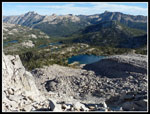
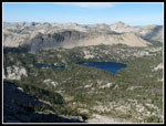
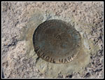
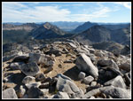
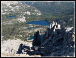
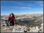
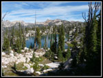
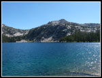
I looked in vain for a summit register. I did find several very rusty tin (not aluminum) cans and a sardine can complete with the rolled up cover. The summit views are stunning. I counted 20 lakes below though I probably missed a few. Ardeth and Ten Lakes Basin are right below. Spangle and Imogene are across Spangle Saddle. Half a dozen drainages were visible, each with multiple lakes. From that elevation you can see most of the Sawtooth summits and many of the White Clouds. The Salmon River Valley was a brown swath in the distance. It is a great view summit and well worth the effort.
I spent a little over half an hour on top and headed down. I made one slight wrong turn before the easy ledge but quickly caught my error and got back on track. 600' of bouldering later I was back on easy terrain. I looked over the edge at a small saddle and found cliffs below. Starting up the other side I looked over the side and found terrain that looked reasonable to descend. I was almost right above the best of the Ten Lakes and dropping down would be much quicker than dropping all the way to Spangle Saddle, dropping to the meadow and climbing back up to the lakes. With that in mind I headed down.
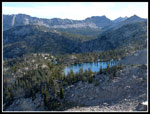
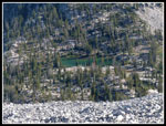
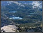
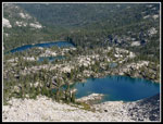
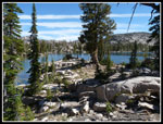
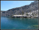
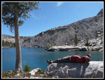
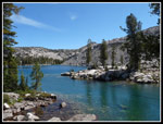
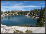
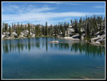
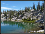
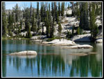
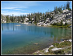
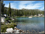
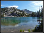
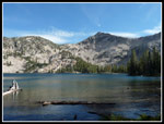
The hillside was grass, boulders and some loose scree. I navigated around the worst of it and made it down to the boulder gully below with little problem. I crossed the gully, climbed up the other side, and had easy terrain from there on. Boulders, open forest, and grass led down to the lake. Having a GPS made it very easy to reach the lake right at the left shore. I found a long deep blue lake ringed with granite. One side was a steep gravel moraine from long ago days of a glacier. I found a granite slab jutting out into the lake for my lunch spot.
What a place. If this was in Washington the permits would all be gone on the first day they were available. Instead I was all alone on a sunny day. The only improvement I could image would be to replace the trees with larches. I wanted to explore more of the lakes but from above I already saw that this was the best of the lot. It was so perfect I lost a lot of motivation. Thirty minutes went by then forty five. Finally, I pried myself from my comfy rock slab and headed around the lake. Another nice lake was a short way down the slope towards Ardeth. I reached this and found another very comfortable rock slab. Warmed by the sun and gently sloping towards the lake. Another nap ensued.
Across the lake in the distance was the ridge where Gary and I had first spied the lakes. It is clear that one could climb the ridge to where it levels off and descend a nice side ridge to the lakes. Perhaps on a future visit. A little more roaming and it was time to head back to camp. The forecast for the next day had thunder and lightening on tap and I did not want to be crossing an exposed 9400' pass in those conditions. Instead I chose to move camp over the first ridge and down to Edna Lake. Then I could cross the high pass early in the morning.
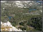
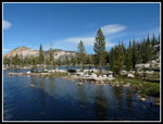
The drop from the granite lakes to the meadow was easy. I stayed just right of another boulder field and reached the flat meadow. A completely dry lake bed sat not far from the trail. I crossed the lake and was back on trail for the first time in 5 hours. Two more lakes sit to the left of the trail in forest. I decided on one more detour. A very short cross country walk brought me to another of the Ten Lakes. Nice but not as impressive as the granite lined lakes above. Now it was back to camp. I broke camp and headed back up the trail. As expected it was now in the high 60s but felt like mid 70s in the sun. I met two forest service trail workers who came up from Elk Lake. Their work is much appreciated. The 600' climb to the saddle above Vernon was not much fun.
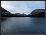
At the saddle I stopped at the little lake and took a break on the long slab pointing out into the lake. A really great spot for a rest. That lasted more than half an hour. It was 5:00 pm before I headed down to Vernon and Edna. At Edna I found a big horse camp and called it home. I set up my tent, hung the food, and sat down to dinner. I found a much better camp on a peninsula nearby but had no interest in moving my camp. I went to bed at 8:15 again. In the previous few hours clouds had rolled in. It was not at all cold when I went to bed.
In fact, it was much warmer on night two. I doubt it fell below 45 degrees. My sleeping bag remained half unzipped all night. I fell asleep very happy with the events of the day. For the day I hiked about 8 miles with 2600' of gain.
I woke up at 6:45 and pulled myself out of my warm sleeping bag at 7:15. Today would be the payoff for the long 14 miles the day before. It was cold but the sun was peeking out. This was to be the warmest day of the week. Not a cloud in the sky. By 8:25 I had my gear packed away in my Osprey Aether 70 "day pack" A little overkill for day hiking but at least it was a lot lighter than the day before. From this point on I had a map, a GPS, and Gary's instructions to guide me. He said "hike to the pass between Ardeth and Spangle Lakes and follow the ridge to the top of Gleans Peak.
Ten Lakes Basin sits on a wide bench 600' above Ardeth and 1200' below Glens. The drop to Ardeth is a sheer granite cliff. From Ardeth below it is not clear that any bench exists. From the ridge above camp the year before we had an up close look at all the lakes and all the granite. The bench drops down to another bench above my camp. More of the ten lakes are here in forest.
My plan was to summit Glens (or at least try), drop back to the saddle, then descend and climb again to the majority of Ten Lakes Basin. First I wanted to get the 1825' climb from Ardeth at 8,228' to Glens Peak at 10,053 out of the way while it was cool and no afternoon haze formed. The trail from the lake ascends gently in forest then meadows and finally switchbacks up the bare slope to Spangle Saddle at about 8900'. Here I had my first look at the ridge and summit of Glens Peak. The ridge had looked pretty mellow from camp. Now it looked to be about 60 degrees near the top. Only Gary's talk about the enjoyable scramble gave me any hope of a solo summit. I'm much more conservative when alone.
I meandered up the wide ridge in forest and granite boulders. Easy going at first. After 600' of climbing I was left with the looming summit block and 600' to go. Now it still looked very tough but maybe possible. That last 600' is all on boulders and talus. I don't think there is a piece of solid rock on the mountain. Fortunately most of the boulders are solidly in place. In places I found bits of a climbers path but the loose sand was slicker than staying on boulders.
The steepest part was just below the false summit but hand and footholds were plentiful. The only bit of route finding was when the ridge had a 12' step and I had to turn right. A wide ledge led to better terrain. Some loose talus here but I was back on boulders quickly. Finding the ledge was the only key to descending easily. The final short steep climb brought me to... the false summit. The real summit is just a few feet higher along the ridge. It took me 1:42 minutes to cover 2.3 miles with 1825' gained from camp to the summit. It was still only 10:06. Not a cloud in the sky though a cold breeze necessitated breaking out my jacket.
I looked in vain for a summit register. I did find several very rusty tin (not aluminum) cans and a sardine can complete with the rolled up cover. The summit views are stunning. I counted 20 lakes below though I probably missed a few. Ardeth and Ten Lakes Basin are right below. Spangle and Imogene are across Spangle Saddle. Half a dozen drainages were visible, each with multiple lakes. From that elevation you can see most of the Sawtooth summits and many of the White Clouds. The Salmon River Valley was a brown swath in the distance. It is a great view summit and well worth the effort.
I spent a little over half an hour on top and headed down. I made one slight wrong turn before the easy ledge but quickly caught my error and got back on track. 600' of bouldering later I was back on easy terrain. I looked over the edge at a small saddle and found cliffs below. Starting up the other side I looked over the side and found terrain that looked reasonable to descend. I was almost right above the best of the Ten Lakes and dropping down would be much quicker than dropping all the way to Spangle Saddle, dropping to the meadow and climbing back up to the lakes. With that in mind I headed down.
The hillside was grass, boulders and some loose scree. I navigated around the worst of it and made it down to the boulder gully below with little problem. I crossed the gully, climbed up the other side, and had easy terrain from there on. Boulders, open forest, and grass led down to the lake. Having a GPS made it very easy to reach the lake right at the left shore. I found a long deep blue lake ringed with granite. One side was a steep gravel moraine from long ago days of a glacier. I found a granite slab jutting out into the lake for my lunch spot.
What a place. If this was in Washington the permits would all be gone on the first day they were available. Instead I was all alone on a sunny day. The only improvement I could image would be to replace the trees with larches. I wanted to explore more of the lakes but from above I already saw that this was the best of the lot. It was so perfect I lost a lot of motivation. Thirty minutes went by then forty five. Finally, I pried myself from my comfy rock slab and headed around the lake. Another nice lake was a short way down the slope towards Ardeth. I reached this and found another very comfortable rock slab. Warmed by the sun and gently sloping towards the lake. Another nap ensued.
Across the lake in the distance was the ridge where Gary and I had first spied the lakes. It is clear that one could climb the ridge to where it levels off and descend a nice side ridge to the lakes. Perhaps on a future visit. A little more roaming and it was time to head back to camp. The forecast for the next day had thunder and lightening on tap and I did not want to be crossing an exposed 9400' pass in those conditions. Instead I chose to move camp over the first ridge and down to Edna Lake. Then I could cross the high pass early in the morning.
The drop from the granite lakes to the meadow was easy. I stayed just right of another boulder field and reached the flat meadow. A completely dry lake bed sat not far from the trail. I crossed the lake and was back on trail for the first time in 5 hours. Two more lakes sit to the left of the trail in forest. I decided on one more detour. A very short cross country walk brought me to another of the Ten Lakes. Nice but not as impressive as the granite lined lakes above. Now it was back to camp. I broke camp and headed back up the trail. As expected it was now in the high 60s but felt like mid 70s in the sun. I met two forest service trail workers who came up from Elk Lake. Their work is much appreciated. The 600' climb to the saddle above Vernon was not much fun.
At the saddle I stopped at the little lake and took a break on the long slab pointing out into the lake. A really great spot for a rest. That lasted more than half an hour. It was 5:00 pm before I headed down to Vernon and Edna. At Edna I found a big horse camp and called it home. I set up my tent, hung the food, and sat down to dinner. I found a much better camp on a peninsula nearby but had no interest in moving my camp. I went to bed at 8:15 again. In the previous few hours clouds had rolled in. It was not at all cold when I went to bed.
In fact, it was much warmer on night two. I doubt it fell below 45 degrees. My sleeping bag remained half unzipped all night. I fell asleep very happy with the events of the day. For the day I hiked about 8 miles with 2600' of gain.
 First light On Glens Peak |
 Glens Summit |
 Glens Summit Ridge |
 Trail Approaching Saddle |
 Lakes & Meadows |
 Summit From Saddle |
 Big Ten Lakes Lake |
 Forested Ten Lakes Lakes |
 Spangles & Peaks |
 Boulders To Summit |
 More Ten Lakes |
 Lake Close Up |
 Many Lakes |
 Looser Rocks Near Top |
 Spangle Lakes |
 Summit Benchmark |
 Summit Of Glens Peak |
 Unnamed Lakes |
 Ardeth From Summit |
 Vernon & Lake 8860 |
 Sawtooth Peaks |
 Self Portait On Ridge |
 Lower Rocky Ridge |
 Next Objective Below |
 My Ridge Descent Route |
 Lake In Sight |
 Peninsula Ahead |
 Rock Slab & Moraine |
 Snooze Time |
 Look Down Lake |
 My Peninsula |
 Next Lake |
 Lake From Granite Slab |
 Lake Reflection |
 Green & Granite |
 Rock Islands |
 Lake View |
 Old & New Trails |
 More Granite |
 Meadow Near Trail |
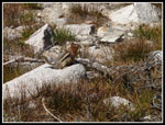 Posing Squirrel |
 Forested Lake |
 Back At Ardeth Lake |
 Lake 8860 |
 Glens In Distance |
 Vernon Lake |
 Edna Lake Sunset |
 Last Light |
<< Photo Page >>
Sawtooth Mountains Report
Home