4/22-23/11
My
business treats Good Friday as a holiday. One day I have off when most
folks are hard at work. This year it looked like two sunny days in a
row after a cold and wet year so far. I needed to get in my first
backpacking trip of the year. For a solo trip I wanted to stick to a
route I knew well and one that a friend also had done on snow. If I did
not report in on Saturday Gary knows the route and would call for help.
Iron Peak is a great viewpoint at 6520'. Mt. Stuart blocks views north
but every other direction is clear. Great sunsets and sunrises too.
I've camped on the summit four previous times (1,
2,
3,
4).
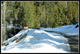
Traffic was light as I headed east. I had been told first that the NF Teanaway Road was clear for 2 1/2 miles but that there were several small washouts. I also heard that the road was snow free to Beverly Campground. That is just beyond where I would head up the Beverly Creek Road. The washouts are not far beyond the end of pavement at 29 Pines Campground. Water is cutting right across the road. I took it slow with my Subaru Outback and had no trouble. A low slung sedan might not do so well. There is a small berm at the bridge over Stafford Creek. No problem there either. The Stafford Creek Road is still completely snow covered.
I continued on beyond the old Guard Station and crossed one patch of icy snow. There was more snow ahead. I chose to turn around and park here where there is ample room. The ice ended soon and the road is mostly snow free to Beverly Creek. What snow there is would not have been a problem. I was on my way by 9:30 am. Walking the 8/10th of a mile of road went fast. The road up Beverly Creek is also completely snow covered. There are a couple bare spots and one tree down about a third of a mile before the summer trailhead.
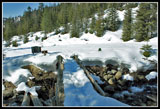
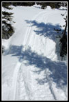
There are a few feet of snow in the parking lot. The bridge across Beverly Creek is snow filled up to the railing. It was cold overnight and the snow was firm. I kept my snowshoes on my pack. Crossing Bean Creek is always a mystery early in the season. It might have a snow bridge all the way across or it might be a raging torrent. I carried dive booties just in case I would have to ford it. The creek was no problem at all. I climbed down snow and crossed small logs for ten feet or so. I stashed my booties and headed on.
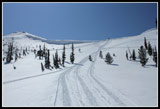
There was a faint ski track heading up the valley. Bean Creek Basin is usually much more popular with skiers. I was surprised to see a track heading up Beverly. A little way beyond the creek the summer trail traverses a steep slope. The skier went straight across leaving a narrow touring ski track. It was completely iced over. I could have used microspikes for this one spot. Instead I headed up the slope kicking steps in the hard snow. part way across I post holed to my crotch. Not so easy to get back out with a winter over night pack on. Once past that spot the going was much easier. I should have put on snowshoes earlier for traction as the ski track was solid ice. In places it was hard to avoid it.
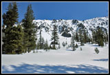
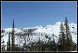
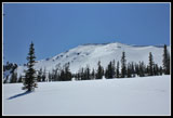
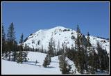
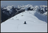
Before I exited the forest I did put on snowshoes. Much better traction. The route broke out into the open lower basin. Blue sky and a heck of a lot of snow for late April. No rocks showing anywhere. Really pretty hiking up the open valley. Bill and Teanaway Peaks came into view. Farther up the track headed towards Beverly Creek. I have crossed the creek down here but usually find better snow bridges higher up. The skier(s) crossed on a narrow snow bridge high over the creek. I decided to pass. Soon I heard the loud droning of snowmobiles. I did not expect to find them in Beverly Basin on a Friday this late in the season. I never did see them but soon came upon the tracks.
I figured that if they crossed the creek there must be a very strong snow bridge nearby. There was. I weigh a little less than a snowmobile and crossed easily. I immediately left the machine track and went back to making my own. I saw the skiers track heading up the valley towards Beverly-Turnpike Pass. I angled up towards the pass between Teanaway and Iron Peaks. The sun had been on the slope of Iron Peak for many hours and I did not want to tempt fate making a long climb to the ridge. Safer to do a short climb to the pass. It's longer but I was solo and not inclined to push my luck.
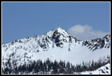
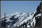
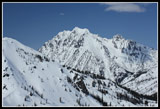
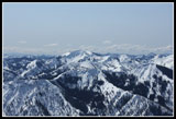
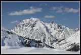
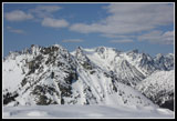
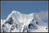
The heat was the first I have felt since last fall. Bright afternoon sun reflecting off the snow and uphill trail breaking slowed me down. The amazing views did too. I dragged my DSLR along on this trip. More weight but with the great conditions it was well worth it. Volcanic Neck, Mary, Judi, and Bean Peaks came into view behind me. Mt. Stuart came into view between Bill and Teanaway Peaks. The last climb to the pass was steep but short. From the ridge top all the peaks to the west came into view. A few clouds over the crest but mostly clear.
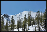
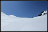
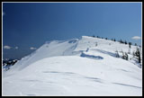
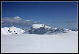
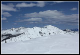
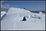
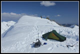
Now I just had a half mile or so with 300' of gain to the summit. The heat was getting to me but I made slow steady progress. There is as much snow on Iron as I have seen on any spring visit over the last twenty five years. No rocks showing at all. Huge cornices hanging over the east side. I usually camp just below the summit near some scrubby trees to the right and some rocks to the left. It is just snow now with a little of the trees showing.
On the positive side it is flat enough that leveling a tent site was easier than usual. I arrived at 3:15 pm, dropped my pack and went to the summit, then set up camp. The summit has a register in a rocky spot. The rocks are buried many feet below snow now. The wind was light and the views spectacular. I spent lots of time with my camera. After dinner the wind picked up and I dove into my tent. I came back out near sunset. There were no clouds left over the crest of the Cascades so the colors were a little muted but still very nice. Definitely one of the best places I have viewed sunset. By 8:30 I was in for the night and the temperature plummeted. No clouds meant a cold night at 6500'.
My Akto is a small and warm tent. I have recorded 5-10 degrees above outside temperatures. I noticed 25 degrees inside the tent for the low. Probably mid to high teens outside. A 2:30 am nature walk was frigid. A pee bottle would have been a good idea. My boots were frozen solid and just getting them on was a battle. In the morning I was up early enough to see the sunrise. About 5:50 am. I stayed in bed until the sun hit the tent and warmed it up.
I was a little worried about glissading off the summit. Too icy hard or too soft. It was a little soft. I slid 400 vertical feet before soft snow stopped me. With snowshoes back on it was a joy to drop down to the creek. Sun on the peaks but too early for glare. Absolutely perfect conditions. I picked up my uphill tracks and followed them down. Across the creek a wide backcountry ski track joined in. It must have followed my track yesterday.
The rest of the trip down was easy walking. The snow was softer on the steep slope and I had no problem. Bean Creek was easy too. I made it back to my car at 12:45. 3:15 minutes down cutting off two hours from my uphill time. I did not see a soul and only heard snowmobiles for a few minutes. Almost total solitude. A summit camp heralds the opening of spring snow scrambling in the Teanaway area. With all this snow there should be many more weeks of it this spring.
Click on thumbnails to get
larger pictures.
Photo Page 2
Trips - 2011
Home
Traffic was light as I headed east. I had been told first that the NF Teanaway Road was clear for 2 1/2 miles but that there were several small washouts. I also heard that the road was snow free to Beverly Campground. That is just beyond where I would head up the Beverly Creek Road. The washouts are not far beyond the end of pavement at 29 Pines Campground. Water is cutting right across the road. I took it slow with my Subaru Outback and had no trouble. A low slung sedan might not do so well. There is a small berm at the bridge over Stafford Creek. No problem there either. The Stafford Creek Road is still completely snow covered.
I continued on beyond the old Guard Station and crossed one patch of icy snow. There was more snow ahead. I chose to turn around and park here where there is ample room. The ice ended soon and the road is mostly snow free to Beverly Creek. What snow there is would not have been a problem. I was on my way by 9:30 am. Walking the 8/10th of a mile of road went fast. The road up Beverly Creek is also completely snow covered. There are a couple bare spots and one tree down about a third of a mile before the summer trailhead.
There are a few feet of snow in the parking lot. The bridge across Beverly Creek is snow filled up to the railing. It was cold overnight and the snow was firm. I kept my snowshoes on my pack. Crossing Bean Creek is always a mystery early in the season. It might have a snow bridge all the way across or it might be a raging torrent. I carried dive booties just in case I would have to ford it. The creek was no problem at all. I climbed down snow and crossed small logs for ten feet or so. I stashed my booties and headed on.
There was a faint ski track heading up the valley. Bean Creek Basin is usually much more popular with skiers. I was surprised to see a track heading up Beverly. A little way beyond the creek the summer trail traverses a steep slope. The skier went straight across leaving a narrow touring ski track. It was completely iced over. I could have used microspikes for this one spot. Instead I headed up the slope kicking steps in the hard snow. part way across I post holed to my crotch. Not so easy to get back out with a winter over night pack on. Once past that spot the going was much easier. I should have put on snowshoes earlier for traction as the ski track was solid ice. In places it was hard to avoid it.
Before I exited the forest I did put on snowshoes. Much better traction. The route broke out into the open lower basin. Blue sky and a heck of a lot of snow for late April. No rocks showing anywhere. Really pretty hiking up the open valley. Bill and Teanaway Peaks came into view. Farther up the track headed towards Beverly Creek. I have crossed the creek down here but usually find better snow bridges higher up. The skier(s) crossed on a narrow snow bridge high over the creek. I decided to pass. Soon I heard the loud droning of snowmobiles. I did not expect to find them in Beverly Basin on a Friday this late in the season. I never did see them but soon came upon the tracks.
I figured that if they crossed the creek there must be a very strong snow bridge nearby. There was. I weigh a little less than a snowmobile and crossed easily. I immediately left the machine track and went back to making my own. I saw the skiers track heading up the valley towards Beverly-Turnpike Pass. I angled up towards the pass between Teanaway and Iron Peaks. The sun had been on the slope of Iron Peak for many hours and I did not want to tempt fate making a long climb to the ridge. Safer to do a short climb to the pass. It's longer but I was solo and not inclined to push my luck.
The heat was the first I have felt since last fall. Bright afternoon sun reflecting off the snow and uphill trail breaking slowed me down. The amazing views did too. I dragged my DSLR along on this trip. More weight but with the great conditions it was well worth it. Volcanic Neck, Mary, Judi, and Bean Peaks came into view behind me. Mt. Stuart came into view between Bill and Teanaway Peaks. The last climb to the pass was steep but short. From the ridge top all the peaks to the west came into view. A few clouds over the crest but mostly clear.
Now I just had a half mile or so with 300' of gain to the summit. The heat was getting to me but I made slow steady progress. There is as much snow on Iron as I have seen on any spring visit over the last twenty five years. No rocks showing at all. Huge cornices hanging over the east side. I usually camp just below the summit near some scrubby trees to the right and some rocks to the left. It is just snow now with a little of the trees showing.
On the positive side it is flat enough that leveling a tent site was easier than usual. I arrived at 3:15 pm, dropped my pack and went to the summit, then set up camp. The summit has a register in a rocky spot. The rocks are buried many feet below snow now. The wind was light and the views spectacular. I spent lots of time with my camera. After dinner the wind picked up and I dove into my tent. I came back out near sunset. There were no clouds left over the crest of the Cascades so the colors were a little muted but still very nice. Definitely one of the best places I have viewed sunset. By 8:30 I was in for the night and the temperature plummeted. No clouds meant a cold night at 6500'.
My Akto is a small and warm tent. I have recorded 5-10 degrees above outside temperatures. I noticed 25 degrees inside the tent for the low. Probably mid to high teens outside. A 2:30 am nature walk was frigid. A pee bottle would have been a good idea. My boots were frozen solid and just getting them on was a battle. In the morning I was up early enough to see the sunrise. About 5:50 am. I stayed in bed until the sun hit the tent and warmed it up.
I was a little worried about glissading off the summit. Too icy hard or too soft. It was a little soft. I slid 400 vertical feet before soft snow stopped me. With snowshoes back on it was a joy to drop down to the creek. Sun on the peaks but too early for glare. Absolutely perfect conditions. I picked up my uphill tracks and followed them down. Across the creek a wide backcountry ski track joined in. It must have followed my track yesterday.
The rest of the trip down was easy walking. The snow was softer on the steep slope and I had no problem. Bean Creek was easy too. I made it back to my car at 12:45. 3:15 minutes down cutting off two hours from my uphill time. I did not see a soul and only heard snowmobiles for a few minutes. Almost total solitude. A summit camp heralds the opening of spring snow scrambling in the Teanaway area. With all this snow there should be many more weeks of it this spring.
 Beverly Creek Junction |
 Snow At Trailhead |
 Bean Creek Crossing |
 Sloughing Snow |
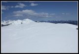
 Upper Basin |
 Solid Snow Bridge |
 Iron Peak |
 Beyond Fourth Ck Pass |
 Iron Glistens |
 Bean Peak |
 Teanaway Peak |
 Snowmobile Raceway |
 Almost To Pass |
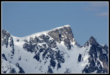
 Hawkins Mountain |
 On The Ridge Of Iron |
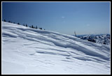 Wind Blasted Patterns |
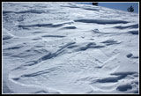 More Patterns |
 Summit In Sight |
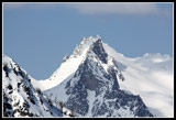
 Mt. Stuart |
 No Rocks On Summit |
 Jolly Mountain |
 Bean, Mary, & Earl Pks |
 Lonely Backpack |
 Dug Out A Tent Site |
 Campsite at 6500' |
 Puffy Clouds & Stuart |
 Bill's & Stuart Range |
 Stuart Close Up |
 Dragontail Peak |
 Little Annapurna |
Photo Page 2
Trips - 2011
Home