4-07-12
Eight
and a half years. Wow! It has been eight and a half years since you
could drive to the end of the Suiattle River Road. For the last five
and a half years it has been a 10 mile walk or bike ride just to get to
the old trailheads. Sulphur
Creek, Sulphur Mountain, Milk Creek, and the Suiattle River trail. Four
trails and a great campground at the end of the road. Off limits to
most hikers. A whole generation is growing up since the closure. Kids
in third grade weren't even born yet. Such a beautiful area and so hard
to get to. That's not even counting the side road to the Green Mountain
trail. In the intervening years I have been back there a few times.
Once to Sulphur
Mountain. and once to Green
Mountain. The west side of the
Glacier Peak Wilderness is one of the most beautiful places you will
ever see. Deep dark forests, high meadows, lakes, and peaks galore.
After eight and a half years we are almost ready to regain access to Buck Creek and Sulphur Creek campgrounds, and seven trails. The Forest Service proposes to repair the road to the end. There are two other alternatives. Do nothing and continue with a 20.8 mile round trip to the end of the road trailheads or repair about half the road and have a 9 to 10 mile round trip. It should be clear by now what I would like to see done. The comment period for public comment on the Environmental Assessment (EA) that outlines the three choices is rapidly ending. All comments must be in by April 20th. WTA also supports repairing the road to the end. WTA has a blog post outlining the choices with links to the EA and where to send comments. http://www.wta.org/trail-news/signpost/suiattle-road-environmental-assessment-released. I have a thread devoted to help with writing a comment from the fix the road perspective here: Suiattle Road Comment Help
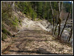
It is important for hikers to have their voices heard on items as important as the Suiattle River Road. Regardless of which alternative you support, I hope you folks will take a few minutes to send in a comment. Well enough of that. Before sending in my comment I wanted to see the road once again. Randy had the same idea so we drove east from Arlington then north to just past the bridge over the Sauk River and onto the Suiattle River Road. The paved section is in very good shape. The dirt section could use a little grading. The turn off to the Boundary Bridge is at mile 10 and the road is gated at mile 12.6. From there is was all on mountain bikes.
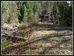
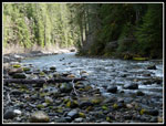
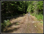
The road is mostly out of sight of the river. It is just in a few places that it is right next to the river bed. The big floods of 2003 and 2006 took out a chunk of the road at the gate. The repair will move the road farther inland to minimize more washouts. The road is still damp making for more work than my previous summer time visits when the harder road surface made for good speed. There are at least a dozen trees down across the road. For the most part branches have been cut off and it's not hard to get over or under them. At 1.8 miles we reached the Huckleberry Mountain trailhead. This is an under used gem of a trail. Evenly graded switchbacks through forest to high meadows near the top. I need to hike it again soon.
The Buck Creek campground is next. Build by the CCC during the 1930s it is a gem. Still in very good shape though out of reach of campers since 2006. There are not a lot of forest campgrounds in Western Washington and this is one of the best. The road climbs slowly with a few ups and downs. The map shows 850' of net gain to the end an I would guess about 1200' - 1400' total elevation gain in and out. Not a lot over nearly 21 miles but enough to have us going into low gear a few times. This valley was logged a century ago and in many cases again. Second and third growth forest. At the end of the road is some old growth that makes these trees pale by comparison.
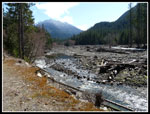
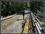
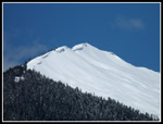
Another hill signaled that we were getting near the Green Mountain Road junction. If Alternative C is chosen then the road would end here and a big parking lot would have to be made. The trails are popular with horsemen as well as hikers so a lot big enough for horse trailers and many cars would be needed. Just like the one that is at the end of the road now. A few miles of ups and downs brought us to another washout and the Downey Creek Bridge. The washout is the one place the road cannot be moved far from the river. The Downey bridge is in fine shape there is just no approach. The floods tore out a chunk of the approach leaving the bridge high and dry. For now a dirt and wood ramp get you up to the bridge deck.
When the bridge was built fill dirt was moved into the creek bed. The repair plan is to remove all that dirt and add three 70' sections that attach to the old bridge. The 150' wide creek will now be able to flow through the whole 360' wide channel ending a constriction point. The plan was approved by National Marine Fisheries, the US Fish & Wildlife Service, and native tribes. The last two miles crosses Sulphur Creek where there was more minor damage as a tree smashed the guard rail on one side and a small gap exists from road to bridge. We encountered snow in two spots near the bridge then the road was bare again. Should be snow free in a week or two at most.
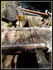
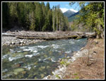
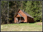
At the end of the road the old parking lot is in good shape. Room for horse trailers and many dozens of cars. We had lunch down on the river in bright sunshine. The day began cold and never did get very warm but the sunshine more than made up for it. The ride back was much faster. We stopped at the old Guard Station. This old cabin was a popular rental before the road washouts. I hope it will be again soon. An amazing waterfall on a steep wall of ferns behind the cabin. With most hills behind us the rest of the ride went fast. I'm looking forward to day hikes of Huckleberry, Green, and Sulphur Mountains once again. Camping at Sulphur campgrounds on a Friday night before backpacking the Suiattle River and Milk Creek trails. It has been a long wait. I hope it's almost over.
Click on thumbnails to get
larger pictures.
Trips - 2012
Home
After eight and a half years we are almost ready to regain access to Buck Creek and Sulphur Creek campgrounds, and seven trails. The Forest Service proposes to repair the road to the end. There are two other alternatives. Do nothing and continue with a 20.8 mile round trip to the end of the road trailheads or repair about half the road and have a 9 to 10 mile round trip. It should be clear by now what I would like to see done. The comment period for public comment on the Environmental Assessment (EA) that outlines the three choices is rapidly ending. All comments must be in by April 20th. WTA also supports repairing the road to the end. WTA has a blog post outlining the choices with links to the EA and where to send comments. http://www.wta.org/trail-news/signpost/suiattle-road-environmental-assessment-released. I have a thread devoted to help with writing a comment from the fix the road perspective here: Suiattle Road Comment Help
It is important for hikers to have their voices heard on items as important as the Suiattle River Road. Regardless of which alternative you support, I hope you folks will take a few minutes to send in a comment. Well enough of that. Before sending in my comment I wanted to see the road once again. Randy had the same idea so we drove east from Arlington then north to just past the bridge over the Sauk River and onto the Suiattle River Road. The paved section is in very good shape. The dirt section could use a little grading. The turn off to the Boundary Bridge is at mile 10 and the road is gated at mile 12.6. From there is was all on mountain bikes.
The road is mostly out of sight of the river. It is just in a few places that it is right next to the river bed. The big floods of 2003 and 2006 took out a chunk of the road at the gate. The repair will move the road farther inland to minimize more washouts. The road is still damp making for more work than my previous summer time visits when the harder road surface made for good speed. There are at least a dozen trees down across the road. For the most part branches have been cut off and it's not hard to get over or under them. At 1.8 miles we reached the Huckleberry Mountain trailhead. This is an under used gem of a trail. Evenly graded switchbacks through forest to high meadows near the top. I need to hike it again soon.
The Buck Creek campground is next. Build by the CCC during the 1930s it is a gem. Still in very good shape though out of reach of campers since 2006. There are not a lot of forest campgrounds in Western Washington and this is one of the best. The road climbs slowly with a few ups and downs. The map shows 850' of net gain to the end an I would guess about 1200' - 1400' total elevation gain in and out. Not a lot over nearly 21 miles but enough to have us going into low gear a few times. This valley was logged a century ago and in many cases again. Second and third growth forest. At the end of the road is some old growth that makes these trees pale by comparison.
Another hill signaled that we were getting near the Green Mountain Road junction. If Alternative C is chosen then the road would end here and a big parking lot would have to be made. The trails are popular with horsemen as well as hikers so a lot big enough for horse trailers and many cars would be needed. Just like the one that is at the end of the road now. A few miles of ups and downs brought us to another washout and the Downey Creek Bridge. The washout is the one place the road cannot be moved far from the river. The Downey bridge is in fine shape there is just no approach. The floods tore out a chunk of the approach leaving the bridge high and dry. For now a dirt and wood ramp get you up to the bridge deck.
When the bridge was built fill dirt was moved into the creek bed. The repair plan is to remove all that dirt and add three 70' sections that attach to the old bridge. The 150' wide creek will now be able to flow through the whole 360' wide channel ending a constriction point. The plan was approved by National Marine Fisheries, the US Fish & Wildlife Service, and native tribes. The last two miles crosses Sulphur Creek where there was more minor damage as a tree smashed the guard rail on one side and a small gap exists from road to bridge. We encountered snow in two spots near the bridge then the road was bare again. Should be snow free in a week or two at most.
At the end of the road the old parking lot is in good shape. Room for horse trailers and many dozens of cars. We had lunch down on the river in bright sunshine. The day began cold and never did get very warm but the sunshine more than made up for it. The ride back was much faster. We stopped at the old Guard Station. This old cabin was a popular rental before the road washouts. I hope it will be again soon. An amazing waterfall on a steep wall of ferns behind the cabin. With most hills behind us the rest of the ride went fast. I'm looking forward to day hikes of Huckleberry, Green, and Sulphur Mountains once again. Camping at Sulphur campgrounds on a Friday night before backpacking the Suiattle River and Milk Creek trails. It has been a long wait. I hope it's almost over.
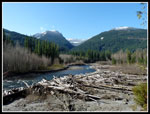 River From Gate |
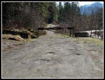 The Current Gate |
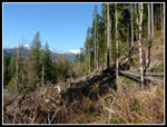 Huckleberry Reroute |
 Buck Creek |
 Before Downey Washout |
 River From Washout |
 Downey Repair Site |
 Downey Creek |
 Sulphur Ck Damage |
 Sulphur Ck Bridge |
 Suiattle Trailhead |
 Green Mountain |
 River From Road End |
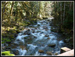
 Serene Suiattle River |
 Road In Great Shape |
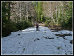 One Snow Patch |
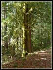 Mossy Trees |
 Guard Station |
Trips - 2012
Home