Page 2
Day
2
Sunday
began sunny and cool. We
were packed up and on the trail by 8:30 am. Cool quickly gave way to
not so cool and short sleeves and shorts were used for the rest of the
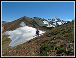
day. From our campsite at about 5750' we contoured and climbed to the
east. Soon we had open views to Mt. Rainer. Rainier had a cloud cap
that warned of a change in the weather. The valleys below were under
low clouds but we had almost entirely blue sky overhead. At our break
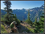
to remove clothing and put on sunscreen I finished first and headed out
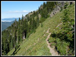
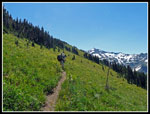
ahead. Now it was mostly open slopes with views south to Johnson Peak
and Hawkeye Point. Some fall leaf color too with bright sunny
backlighting. More ripe huckleberries slowed my pace. The trail has
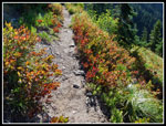
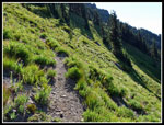
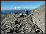
narrowed markedly over the years. It is quite narrow is spots. There
are a couple slopes prone to washouts that have no vegetation. The
track across them is skimpy but sufficient. There were more logs down
across the way but again, with one exception all could be crossed
without much difficulty. It does not look like there will be any
logging out done on the trails from Packwood Lake to Lost Lake,
Packwood Saddle, and back to Packwood Lake this year.
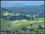
I stopped to talk with two hikers and Gary and John caught up with me. The other two were doing a loop similar to our in reverse. They came up to Packwood Saddle and Elk Pass and were now retracing our steps back to the trailhead. We had been debating camping at Packwood Saddle vs. Elk Pass Sunday night. The saddle is forested while the pass is 1100' higher and has great views. If the clouds came in as forecast hiking down from the pass on Monday in the rain did not sound like a lot of fun. On the other hand, if it remained clear the pass is much nicer. The other hikers mentioned seeing a group at Packwood Saddle and that they were heading out this morning.
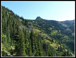
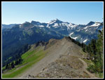
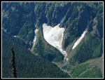
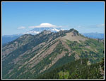
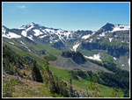
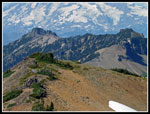
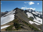
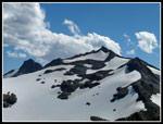
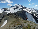
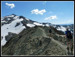
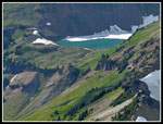
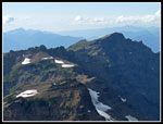
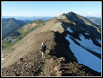
We continued along the Coyote Ridge Trail. We climbed as high as 6350' before descending towards Packwood Saddle at about 5550'. The last part is right on the ridge top. Views opened up to the east, south, and west. Old Snowy and Elk Pass were now in sight. Across the valley below Johnson were waterfalls and ice caves below big snowfields. Very good views all around. As we neared Packwood Saddle we met another group of backpackers heading up Coyote Ridge. Not crowded but more folks than we expected. Packwood Saddle is in forest. No views. Lots of flies. Although our map listed a spring just below the pass a quick search did not snow one. The first group of backpackers in Coyote Ridge mentioned a good campsite a ways below the pass right on a creek and that it was taken. With the saddle not looking at all appealing we chose to haul our packs up to Elk Pass.
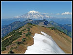
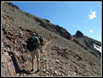
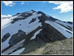
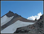
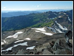
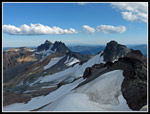
It was getting very warm as the steadily graded trail left forest for more open slopes. It was noon and there would be precious little shade for the rest of the day. Not good conditions for me. I slowed down and kept up a steady pace. More logs across the trail. Gary stopped counting when the trip total reached forty. I reached Elk Pass a few minutes before the others. Fantastic views in all directions. We were not alone as I saw three or four groups nearby and others occasionally heading north. It is time for a lot of Pacific Crest Trail through hikers to pass on their way from Mexico to Canada. It felt like at least 80 degrees. Our plan was to find a camp and then head south along the PCT to the summit of Old Snowy Mountain. There is still some snow on the east side of the ridge crest but running water is several hundred feet below in a broad basin.
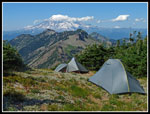
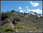
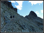
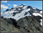
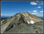
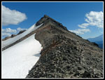
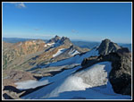
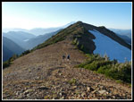
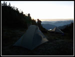
We expected to descend down to the basin but found a good campsite near the ridge top. After setting up camp we followed the PCT down and filled tow water bags with ice cold water right out of the snowfield. Gary climb over to a spot where the water was out of and onto the snow to fill his bag. We climbed cross country straight up the slope to our camp. With much lighter packs we headed out for Old Snowy. This is one of the most interesting sections of the PCT. The trail climbs rocky slopes on tread blasted from the hillside. Once up those spots the route truly does become "The Crest Trail". It is right on the ridge top in a number of spots. Very long and steep drops on both sides. We spotted several goat herds on both sides far below.
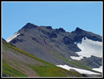
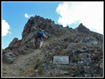
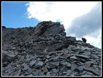
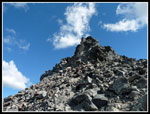
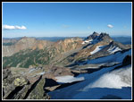
We also met some of the characters on their way from Mexico. One person carrying a ukulele in a case. Another oddity I did not even notice until looking at photos at home. He had a tennis racket strapped to his backpack. Interesting folks. The route has a number of ups and downs to add to the fun. We finally reached the low spot and began the final climb. The old Cascade Crest Trail followed the ridge to near the op of Old Snowy. The new trail breaks off and traverses below the ridge. We headed straight up. What looks to be impossibly steep at a distance proves to be comfortable to ascend. Much of the way is on small dinner plate sized pieces of thin rock that were blasted out. At the high point we left the main trail for the scramble route up Old Snowy. It is not a very difficult scramble though it looks tougher near the top. We could see several groups ahead of us.
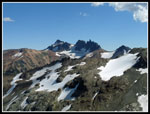
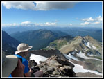
I passed one group and when I reached the top it was pretty crowded. Probably at least ten folks counting us. The views were terrific. Down the ridge were Mt. Gilbert and Ives Peak. Tieton Peak across the way. Goat Lake was in sight. It still is partially snow covered at the start of September. Down at Snowgrass Flats were hordes of hikers including most of our summit friends. As groups headed down the crowd thinned. Two arrivals were PCT through hikers. We ended up talking to them for quite awhile. Nice guys and glad to talk about their adventure. Their biggest mileage day of their trip was 1 1/2 times the distance of our whole three day trip. Everything needs to be put in perspective. I arrived on top at 4:20 pm and did not leave until 5:15 pm. Almost an hour on top. A cool breeze blew on the ridge top most of our way and it made a big difference to me. No shade but the cool breeze kept me going. On the way down it was blowing even harder.
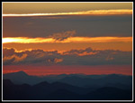
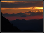
We made good time coming back. Once back at camp we had only to eat dinner, admire the sunset, and head to bed. Contrary to the forecast the sky was still clear as the stars came out. For the day we hiked about 11 miles with 4500' of elevation gain. That added up to 22 miles and 8500' of gain the first two days. Day three would be mostly downhill though the longest day of the trip.
I stopped to talk with two hikers and Gary and John caught up with me. The other two were doing a loop similar to our in reverse. They came up to Packwood Saddle and Elk Pass and were now retracing our steps back to the trailhead. We had been debating camping at Packwood Saddle vs. Elk Pass Sunday night. The saddle is forested while the pass is 1100' higher and has great views. If the clouds came in as forecast hiking down from the pass on Monday in the rain did not sound like a lot of fun. On the other hand, if it remained clear the pass is much nicer. The other hikers mentioned seeing a group at Packwood Saddle and that they were heading out this morning.
We continued along the Coyote Ridge Trail. We climbed as high as 6350' before descending towards Packwood Saddle at about 5550'. The last part is right on the ridge top. Views opened up to the east, south, and west. Old Snowy and Elk Pass were now in sight. Across the valley below Johnson were waterfalls and ice caves below big snowfields. Very good views all around. As we neared Packwood Saddle we met another group of backpackers heading up Coyote Ridge. Not crowded but more folks than we expected. Packwood Saddle is in forest. No views. Lots of flies. Although our map listed a spring just below the pass a quick search did not snow one. The first group of backpackers in Coyote Ridge mentioned a good campsite a ways below the pass right on a creek and that it was taken. With the saddle not looking at all appealing we chose to haul our packs up to Elk Pass.
It was getting very warm as the steadily graded trail left forest for more open slopes. It was noon and there would be precious little shade for the rest of the day. Not good conditions for me. I slowed down and kept up a steady pace. More logs across the trail. Gary stopped counting when the trip total reached forty. I reached Elk Pass a few minutes before the others. Fantastic views in all directions. We were not alone as I saw three or four groups nearby and others occasionally heading north. It is time for a lot of Pacific Crest Trail through hikers to pass on their way from Mexico to Canada. It felt like at least 80 degrees. Our plan was to find a camp and then head south along the PCT to the summit of Old Snowy Mountain. There is still some snow on the east side of the ridge crest but running water is several hundred feet below in a broad basin.
We expected to descend down to the basin but found a good campsite near the ridge top. After setting up camp we followed the PCT down and filled tow water bags with ice cold water right out of the snowfield. Gary climb over to a spot where the water was out of and onto the snow to fill his bag. We climbed cross country straight up the slope to our camp. With much lighter packs we headed out for Old Snowy. This is one of the most interesting sections of the PCT. The trail climbs rocky slopes on tread blasted from the hillside. Once up those spots the route truly does become "The Crest Trail". It is right on the ridge top in a number of spots. Very long and steep drops on both sides. We spotted several goat herds on both sides far below.
We also met some of the characters on their way from Mexico. One person carrying a ukulele in a case. Another oddity I did not even notice until looking at photos at home. He had a tennis racket strapped to his backpack. Interesting folks. The route has a number of ups and downs to add to the fun. We finally reached the low spot and began the final climb. The old Cascade Crest Trail followed the ridge to near the op of Old Snowy. The new trail breaks off and traverses below the ridge. We headed straight up. What looks to be impossibly steep at a distance proves to be comfortable to ascend. Much of the way is on small dinner plate sized pieces of thin rock that were blasted out. At the high point we left the main trail for the scramble route up Old Snowy. It is not a very difficult scramble though it looks tougher near the top. We could see several groups ahead of us.
I passed one group and when I reached the top it was pretty crowded. Probably at least ten folks counting us. The views were terrific. Down the ridge were Mt. Gilbert and Ives Peak. Tieton Peak across the way. Goat Lake was in sight. It still is partially snow covered at the start of September. Down at Snowgrass Flats were hordes of hikers including most of our summit friends. As groups headed down the crowd thinned. Two arrivals were PCT through hikers. We ended up talking to them for quite awhile. Nice guys and glad to talk about their adventure. Their biggest mileage day of their trip was 1 1/2 times the distance of our whole three day trip. Everything needs to be put in perspective. I arrived on top at 4:20 pm and did not leave until 5:15 pm. Almost an hour on top. A cool breeze blew on the ridge top most of our way and it made a big difference to me. No shade but the cool breeze kept me going. On the way down it was blowing even harder.
We made good time coming back. Once back at camp we had only to eat dinner, admire the sunset, and head to bed. Contrary to the forecast the sky was still clear as the stars came out. For the day we hiked about 11 miles with 4500' of elevation gain. That added up to 22 miles and 8500' of gain the first two days. Day three would be mostly downhill though the longest day of the trip.
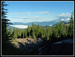 Clouds In The Valley |
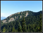 View Of Coyote Ridge |
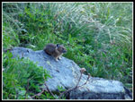 Pika On Rock |
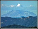 Mt. St. Helens |
 Clothing Break |
 View Ahead |
 Fall Colors |
 Wildflowers |
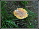 Another Mushroom |
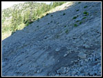 Sketchy Trail |
 Sun Lit Brush |
 Looking Back |
 Saddle Below |
 Ice Cave |
 Open Slopes |
 Cloud Cap |
 Egg Butte |
 Blasted PCT |
 Getting Water |
 Elk Pass Campsite |
 Heading For Old Snowy |
 Elk Pass & Coyote Rdg |
 Elk Pass Below |
 Gary & John |
 Heading For Blast Spot |
 Narrow Trails |
 Blessed Shade |
 Mt. Gilbert |
 Zoomed Old Snowy |
 Great Ridge Walk |
 On The Ridge Top |
 Ridge Behind Us |
 On The PCT |
 Goats Below |
 One More Descent |
 PCT Junction |
 Rock Slabs |
 Almost To Scramble |
 Starting Scramble |
 Summit Block |
 Goat Lake |
 Gary & John On Summit |
 Snowgrass Flats |
 Goat Lake & Feet |
 Johnson Peak |
 Gilbert & Ives |
 Clouds Are Gone |
 Tieton Peak |
 Heading Back |
 On The Ridge Top |
 Back At Elk Pass |
 Great Sunset Views |
 Another Sunset Shot |
 Camp At Sunset |
<< Report Page >>
Goat Rocks Loop Report
Home