Day 2
We
awoke to more clear skies and were packed up and on the trail by 7:55
am. This day we had to drop 2 miles down to the Duckabush River losing
1400'. From there we headed west, up the river, to Marmot Lake and then
up again to LaCrosse Basin with Hart and LaCrosse Lakes. Gary and I
had long wished to visit this alpine highland. Initially we planned to
camp at Lake LaCrosse but began to thing about camping at Marmot Lake
and day hiking up to the basin. The trail was in good shape down to the
Duckabush. Logs had been sawed out the first day but most of the rest
of the way we had recent down logs to get over. Not really very many to
deal with. This would prove to be the last hot day. Back up into the
80s even at over 5000'.
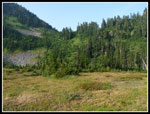
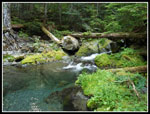
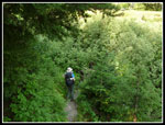
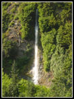
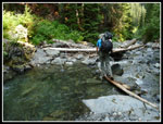
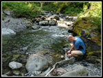
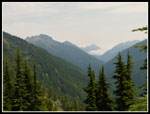
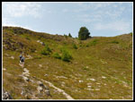
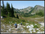
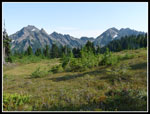
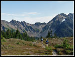
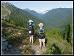
The Upper Duckabush trail was frustrating. Many ups and downs seemed to gain us little elevation. The downs were often steep drops to overgrown meadow creek crossings and then steeply up again. This might not have been a problem with light day packs but with a little over 30 lbs. on my back it was tedious. There were a few really nice waterfalls above us that helped pass the time. One group we talked to had hiked on a much hotter day earlier in the week and had taken 10 hours to reach Marmot Lake from Nine Stream. At long last we dropped down again and reached the crossing of the Duckabush.
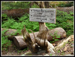
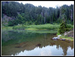
The folks we met at Home Sweet Home were day hiking to LaCrosse Basin and they caught up with us here. We pumped some water and started up the final push to Marmot Lake. The good news is that the trail was graded steadily uphill. The bad news is it was largely out in the very warm sunshine. This was the last and the worst hot section of the trip for me. We soon reached Marmot Lake and decided to camp there. The group site as large enough but had a lot of roots. Tough to fit in three tents. We were the only ones who camped at the lake that night.
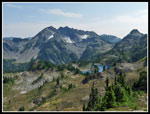
With camp set up we headed up the trail to LaCrosse Basin with much lighter packs. This was the spot Gary and I had wanted to see for many years. A short steep .60 miles and we reached a junction. Left to Hart Lake and right to Lake LaCrosse. We headed for Hart Lake first. A lone hiker now caught up and passed us. He started at Obstruction Point at the north end of the park. A short half mile trail brought us to Hart Lake. It is much larger than Marmot Lake and sits in a bowl. Steep hillside on three sides and nearly flat grass where we reached it. Our friends from Home Sweet Home were enjoying a stay at the lake. We had other plans.
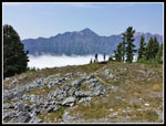
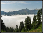
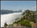
When Opus visited a month earlier he took a trail to the pass north of the lake and then dropped down to the trail that traverses above the East Fork of the Quinault River and the Enchanted Valley. We were mostly interested in reaching the ridge top. The trail climbed steeply then more gently our of the Hart Lake Basin into a higher one then up the grassy slopes to the pass. There were tarns in the upper basin though they were mostly dry already. We received quite a surprise as we topped out on the ridge top. Below us the Enchanted Valley was under a thick layer of fog/clouds. We were in hot sunshine and a just below us it was damp and dark. We took a break at what we referred to as Hart Pass enjoying the views.
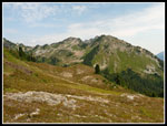
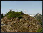
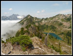
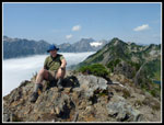
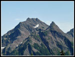
After a while we headed north from the pass. John and Gary went ahead. I sat in the shade and relaxed. A little later they hollered my name and I headed up the ridge. Easy scrambling brought me to the little summit they were enjoying. The views were much better from there. Lake LaCrosse was now visible below. Peaks stood out on all sides. At the head of the Quinault Valley stood the West Peak of Mt. Anderson. A glacier stood out against the bare rock. An alpine lake on one side, a glacier ahead, and a cloud filled valley on the other side. What a neat spot! I would not have minded spending a few hours up there but we had more to see.
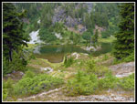
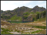
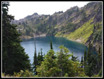
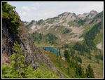
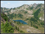
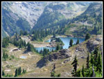
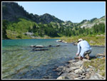
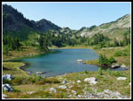
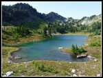
We headed back to the pass then down the trail. A little cross country travel on open terrain brought us to the trail to Lake LaCrosse. More berries here just like so many other places on this trip. Very surprisingly, with all those ripe berries we did not see a single bear for the five day trip. The lake is 1.4 miles from Marmot Lake. Some ups and downs and then we crossed the outlet and dropped to the 4754' lakeshore. No disappointments. This basin and lake was every bit as beautiful as we had hoped. Grass and heather ringed the lake with pockets of evergreen trees. A good place to dip ones feet in the water and relax. As I sat by the lake clouds from over the Enchanted Valley spilled across the ridge. They disappeared in the hot air of the basin. Quite an unusual sight.
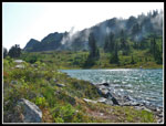
All to soon we packed up and headed back. The basin is not flat and we had several hundred feet of elevation to gain back to the Hart Lake junction. There were still some wildflowers blooming in the basin. The most numerous was gentian. This late season bloomer was seen in many places on our trip. We dropped down to our camp near Marmot Lake and cooked dinner. Later we took a walk over to the lake. We could see that clouds were now sometimes obscuring O'Neil Pass. The weather was changing. By 9:00 pm we were off to bad. Still three more days to go.
For the day we hiked about 9.3 miles with 3150' of elevation gain.
The Upper Duckabush trail was frustrating. Many ups and downs seemed to gain us little elevation. The downs were often steep drops to overgrown meadow creek crossings and then steeply up again. This might not have been a problem with light day packs but with a little over 30 lbs. on my back it was tedious. There were a few really nice waterfalls above us that helped pass the time. One group we talked to had hiked on a much hotter day earlier in the week and had taken 10 hours to reach Marmot Lake from Nine Stream. At long last we dropped down again and reached the crossing of the Duckabush.
The folks we met at Home Sweet Home were day hiking to LaCrosse Basin and they caught up with us here. We pumped some water and started up the final push to Marmot Lake. The good news is that the trail was graded steadily uphill. The bad news is it was largely out in the very warm sunshine. This was the last and the worst hot section of the trip for me. We soon reached Marmot Lake and decided to camp there. The group site as large enough but had a lot of roots. Tough to fit in three tents. We were the only ones who camped at the lake that night.
With camp set up we headed up the trail to LaCrosse Basin with much lighter packs. This was the spot Gary and I had wanted to see for many years. A short steep .60 miles and we reached a junction. Left to Hart Lake and right to Lake LaCrosse. We headed for Hart Lake first. A lone hiker now caught up and passed us. He started at Obstruction Point at the north end of the park. A short half mile trail brought us to Hart Lake. It is much larger than Marmot Lake and sits in a bowl. Steep hillside on three sides and nearly flat grass where we reached it. Our friends from Home Sweet Home were enjoying a stay at the lake. We had other plans.
When Opus visited a month earlier he took a trail to the pass north of the lake and then dropped down to the trail that traverses above the East Fork of the Quinault River and the Enchanted Valley. We were mostly interested in reaching the ridge top. The trail climbed steeply then more gently our of the Hart Lake Basin into a higher one then up the grassy slopes to the pass. There were tarns in the upper basin though they were mostly dry already. We received quite a surprise as we topped out on the ridge top. Below us the Enchanted Valley was under a thick layer of fog/clouds. We were in hot sunshine and a just below us it was damp and dark. We took a break at what we referred to as Hart Pass enjoying the views.
After a while we headed north from the pass. John and Gary went ahead. I sat in the shade and relaxed. A little later they hollered my name and I headed up the ridge. Easy scrambling brought me to the little summit they were enjoying. The views were much better from there. Lake LaCrosse was now visible below. Peaks stood out on all sides. At the head of the Quinault Valley stood the West Peak of Mt. Anderson. A glacier stood out against the bare rock. An alpine lake on one side, a glacier ahead, and a cloud filled valley on the other side. What a neat spot! I would not have minded spending a few hours up there but we had more to see.
We headed back to the pass then down the trail. A little cross country travel on open terrain brought us to the trail to Lake LaCrosse. More berries here just like so many other places on this trip. Very surprisingly, with all those ripe berries we did not see a single bear for the five day trip. The lake is 1.4 miles from Marmot Lake. Some ups and downs and then we crossed the outlet and dropped to the 4754' lakeshore. No disappointments. This basin and lake was every bit as beautiful as we had hoped. Grass and heather ringed the lake with pockets of evergreen trees. A good place to dip ones feet in the water and relax. As I sat by the lake clouds from over the Enchanted Valley spilled across the ridge. They disappeared in the hot air of the basin. Quite an unusual sight.
All to soon we packed up and headed back. The basin is not flat and we had several hundred feet of elevation to gain back to the Hart Lake junction. There were still some wildflowers blooming in the basin. The most numerous was gentian. This late season bloomer was seen in many places on our trip. We dropped down to our camp near Marmot Lake and cooked dinner. Later we took a walk over to the lake. We could see that clouds were now sometimes obscuring O'Neil Pass. The weather was changing. By 9:00 pm we were off to bad. Still three more days to go.
For the day we hiked about 9.3 miles with 3150' of elevation gain.
 First Divide From Camp |
 Junction Sign |
 Creek Crossing |
 White Fungus |
 Into The Brush |
 Nearby Waterfall |
 Crossing Duckabush |
 Filtering Water |
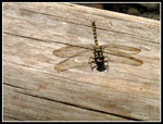 Dragonfly |
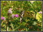 Butterfly |
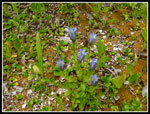 Gentian |
 Marmot Lake |
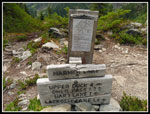 Marmot Lake Signs |
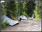 Campsite Night 2 |
 Clouds Down Valley |
 Hart Lake |
 Above Hart Lake |
 Nearing "Hart Pass" |
 Improving Views |
 Above Sea Of Clouds |
 Thick Fog Below |
 Lake LaCrosse View |
 Guys On Summit |
 Edge Of Fog |
 Clouds & Basin |
 Me On The Summit |
 LaCrosse Basin |
 Hart Lake Below |
 Mt. Duckabush |
 Descending To Basin |
 Lake LaCrosse Shore |
 Clouds Roll In |
 Lake LaCrosse |
 Another Lake Shot |
 Mt. Steel |
 Nearby Peaks |
 Crossing Meadows |
 Duckabush Valley View |
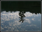 Marmot Lake Reflection |
 Evening @ Marmot Lake |
<< Day >>
Olympic Mountains Loop Report
Home