3-25-16
Good
Friday is a holiday in my business. It is one day each year when I go
hiking and few others do. A chance for a midweek day hike with lots of
solitude. This year Gary joined me. There was a dump of new snow in the
mountains and more in the morning. Rain over the rest of the area west
of the Cascade crest. To the north the weather was much better. I did a
loop on Chuckanut Mountain last year and planned for a return trip.
Gary had not been there. Time for a return visit. Gary headed early to
North Seattle and we were on our way by 7:00 am. Traffic was amazingly
non existent. Virtually no slow downs all the way. It was overcast in
Seattle and began to lighten a little as we went north. I took exit
246, turned right and over I-5 then right again on Old Samish Road. We
went past the Pine and Cedar Lakes Trailhead. I did my first hike there
earlier this year. At Chuckanut Drive I turned left then quickly left
again into the North Chuckanut Mountain parking lot. There
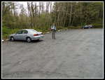
were a couple cars there. We packed up and were on our way by 8:30 am.
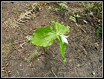
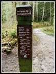
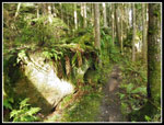
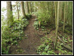
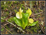
Last year I did this hike in mid May. There were a lot of wildflowers in bloom. This year we were a little early for wildflowers. There were a few exceptions. We saw skunk cabbage near the start and in a number of other spots. I also saw a few blooming trillium in one spot and one small patch of bleeding hearts. There are a number of paths and trails that do not show up on maps. Major intersections trail junctions are well signed. The others not at all. My memory proved good but not infallible We hiked the Interurban Trail to the Hemlock Trail and then right on the North Lost Lake Trail. We met a couple of hikers who were out on spring break at Western Washington University.
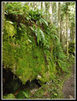
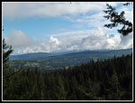
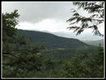
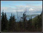
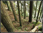
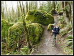
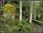
At the next junction we went right on the Chuckanut Ridge Trail. The old roads below gave way to a narrow trail up the at times very narrow ridge. We quickly came to what I'm sure is a good viewpoint of Mt. Baker. After two trips I still have no proof. Eventually I'll get a clear day. It started clearing up then the clouds came back in. The views from the ridge are to the east. Though salt water is close to the west the forest blocks the view. The drops from the viewpoints are nearly vertical. In some cases it seemed more than vertical. Our route back would be right below in the forest.
The ridge is far from a steady uphill slog. There are a number of ups and downs along the way. We completely missed the first trail that drops down to the road below. I saw a signed junction last year. Not sure how we missed it. The second trail heading right from the ridge is one I took last year. After dropping 125' I climbed back up. That one is also not on any maps. This time I knew to stay on the ridge. Eventually the route reached the road and we walked the short distance to the Cyrus Gates Overlook. There was one car in the lot. Ironically, there was blue sky over the water and it was clearing a bit overhead as a few drops of rain started. That was the story of the day. When fully overcast it was dry. when we saw some blue overhead we had a little drizzle. It never rained enough to think about taking out our umbrellas.
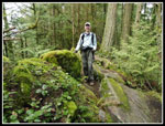
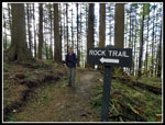
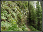
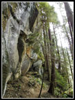
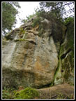
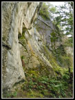
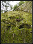
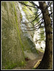
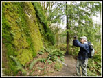
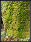
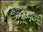
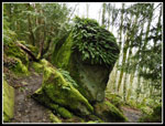
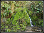
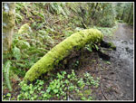
It was chilly at the 1820' overlook. About 49 degrees and it felt colder. Cool enough for jackets. We met the Western folks again here. They planned to go to Lost Lake but continued up the Rock Trail to do our loop in reverse. After lunch at the overlook we headed over to the Rock Trail. This new trail is one of my favorites. It rapidly drops down an amazingly steep slope and traverses just under a big near vertical sandstone wall. The drop begins with a series of step steps. Along with the rock there is a lot of multi colored mosses along the trail.
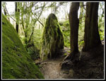
We made slow progress on the Rock Trail. The overcast sky really brought out the colors in the rock and the moss. I was surprised to see several other groups hiking up the trail. At the base of the Rock Trail we headed over towards Lost Lake. The tread was pretty muddy at first then was much drier. It just took a few minutes to reach the unmarked side trail over to a spot on the shore. The lake is surrounded by trees and brush, most of which is salal. It was a muddy track last May and I expected it to be worse after a wet winter. In fact, it was not too bad. We tried to find a spot with a view down the lake with mixed success.
We headed back to the North Lost Lake Trail and began thee lightly uphill trek right under the ridge route we had hike earlier in the day. This part is back on an old road. Lots more moss and a few big rock walls too. Several miles later we reached the junction with the Chuckanut Ridge Trail and closed our loop. The last 2.2 miles was almost all downhill. We met a few bicyclers and hikers. Some coming up and some heading down. We saw a number of folks during the day but it was never close to being crowded. Some of the junctions did not seem familiar and we did consult the GPS a couple times to make sure we were on the right route. Keep making left turns and it works out fine. We made it back to the parking lot at 3:25 pm.
The drive home was very easy. Almost all the way at the speed limit once again. Gary had a little more difficulty getting through Seattle though that too was not as bad as feared. To add to the traffic, Bernie Sanders spoke at Safeco Field a day before the state presidential caucuses. We had a great time. The rain held off, the crowds were minimal and the ridge trail and Rock Trail are well worth the effort to hike. This hike is on my schedule for winter - early spring when I want a snow free hike with lots of miles possible. For the day we hiked about 11.5 miles with 2700' of gain. Not a bad gain when the highpoint of the day was only 1820'.
Click on thumbnails to get
larger pictures.
Trips - 2016
Home
Last year I did this hike in mid May. There were a lot of wildflowers in bloom. This year we were a little early for wildflowers. There were a few exceptions. We saw skunk cabbage near the start and in a number of other spots. I also saw a few blooming trillium in one spot and one small patch of bleeding hearts. There are a number of paths and trails that do not show up on maps. Major intersections trail junctions are well signed. The others not at all. My memory proved good but not infallible We hiked the Interurban Trail to the Hemlock Trail and then right on the North Lost Lake Trail. We met a couple of hikers who were out on spring break at Western Washington University.
At the next junction we went right on the Chuckanut Ridge Trail. The old roads below gave way to a narrow trail up the at times very narrow ridge. We quickly came to what I'm sure is a good viewpoint of Mt. Baker. After two trips I still have no proof. Eventually I'll get a clear day. It started clearing up then the clouds came back in. The views from the ridge are to the east. Though salt water is close to the west the forest blocks the view. The drops from the viewpoints are nearly vertical. In some cases it seemed more than vertical. Our route back would be right below in the forest.
The ridge is far from a steady uphill slog. There are a number of ups and downs along the way. We completely missed the first trail that drops down to the road below. I saw a signed junction last year. Not sure how we missed it. The second trail heading right from the ridge is one I took last year. After dropping 125' I climbed back up. That one is also not on any maps. This time I knew to stay on the ridge. Eventually the route reached the road and we walked the short distance to the Cyrus Gates Overlook. There was one car in the lot. Ironically, there was blue sky over the water and it was clearing a bit overhead as a few drops of rain started. That was the story of the day. When fully overcast it was dry. when we saw some blue overhead we had a little drizzle. It never rained enough to think about taking out our umbrellas.
It was chilly at the 1820' overlook. About 49 degrees and it felt colder. Cool enough for jackets. We met the Western folks again here. They planned to go to Lost Lake but continued up the Rock Trail to do our loop in reverse. After lunch at the overlook we headed over to the Rock Trail. This new trail is one of my favorites. It rapidly drops down an amazingly steep slope and traverses just under a big near vertical sandstone wall. The drop begins with a series of step steps. Along with the rock there is a lot of multi colored mosses along the trail.
We made slow progress on the Rock Trail. The overcast sky really brought out the colors in the rock and the moss. I was surprised to see several other groups hiking up the trail. At the base of the Rock Trail we headed over towards Lost Lake. The tread was pretty muddy at first then was much drier. It just took a few minutes to reach the unmarked side trail over to a spot on the shore. The lake is surrounded by trees and brush, most of which is salal. It was a muddy track last May and I expected it to be worse after a wet winter. In fact, it was not too bad. We tried to find a spot with a view down the lake with mixed success.
We headed back to the North Lost Lake Trail and began thee lightly uphill trek right under the ridge route we had hike earlier in the day. This part is back on an old road. Lots more moss and a few big rock walls too. Several miles later we reached the junction with the Chuckanut Ridge Trail and closed our loop. The last 2.2 miles was almost all downhill. We met a few bicyclers and hikers. Some coming up and some heading down. We saw a number of folks during the day but it was never close to being crowded. Some of the junctions did not seem familiar and we did consult the GPS a couple times to make sure we were on the right route. Keep making left turns and it works out fine. We made it back to the parking lot at 3:25 pm.
The drive home was very easy. Almost all the way at the speed limit once again. Gary had a little more difficulty getting through Seattle though that too was not as bad as feared. To add to the traffic, Bernie Sanders spoke at Safeco Field a day before the state presidential caucuses. We had a great time. The rain held off, the crowds were minimal and the ridge trail and Rock Trail are well worth the effort to hike. This hike is on my schedule for winter - early spring when I want a snow free hike with lots of miles possible. For the day we hiked about 11.5 miles with 2700' of gain. Not a bad gain when the highpoint of the day was only 1820'.
 Trailhead Lot |
 Waterfall |
 Trillium |
 Trail Sign |
 Rocks On Ridge Trail |
 Very Mossy Rock |
 Cloudy Viewpoint |
 Gary On Ridge |
 Unsigned Junction |
 More Clouds |
 Cyrus Gates Overlook |
 Rock Trail |
 Steep Stairways |
 Traversing |
 Sandstone Cliffs |
 Nearly Vertical |
 Curves |
 Mossy Cliff |
 Curved Tree |
 Neat Rocks |
 Gary At Work |
 Stripes |
 Gary & Mossy Rocks |
 Sandstone Pockets |
 Skunk Cabbage |
 Rock Along Trail |
 Ferns |
 Green Hair |
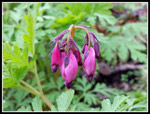 Bleeding Hearts |
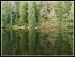 Lost Lake Reflection |
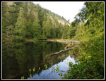 Near End Of Lake |
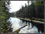 Far End Reflection |
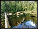 Lost Lake |
 Moss & Waterfall |
 Last Mossy Goodness |
Trips - 2016
Home