7-30-16
I've
known about this hike for decades. A long hike along the Cascade Crest
with a peak and a lake. The surprising part is that I had not ever
hiked it. I have done four winter trips to Mt. McCausland, including
this past
January. This day I could drive
the first three miles of Smith Brook Road. It is a long trip at about
16 miles round trip. With that in mind I had an early start. I was on
the road by 6:00 am. East on Highway 2 across Stevens Pass. Low clouds
were overhead much of the way. It was supposed to be sunny. Not in the
morning at least. About four miles beyond the pass I turned left across
the westbound lanes and onto Smith Brook Road. The road has been
recently graded and my sedan had no problems. I arrived at the small
lot at about 7:40 am. Five minutes later I was on the trail. The lot
holds only 12-15 cars. As I learned at the end of the hike, there is
room for many more parked along the road.
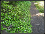
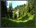
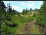
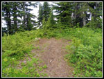
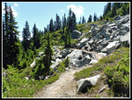
I had been to this point on the four winter trips. I had gone up on both sides of Smith Brook. The real trail is right of the brook. Right about where we went up on several winter trips. It is a little brushy at the start and the brush was still wet. Though the lot had 8-10 cars in it I guess that I was the first person going up this day. There were no more brushy spots the rest of the day. The trail gains about 700' from 4000' to 4680 at Union Gap in roughly 1.3 miles. The forest service website says it is .9 miles to Union Gap. The hand drawn map at the trailhead says 1.5 miles. No two books agree. My GPS says about 1.3. The trail used to start above where the road switchbacks. Now it starts right out of the lot and can also be reached from the road switchback.
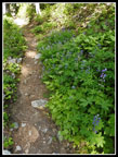
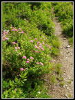
I headed out at a good pace as the route switchbacks uphill. Before long I reached the Henry Jackson Wilderness sign. The trail is well graded as it climbs the slope. I reached the Pacific Crest Trail (PCT) at Union Gap. The winter route starts out the same but stays farther left as it heads for Mt. McCausland. A left turn at the gap heads south on the PCT. Many folks go this way to Lake Valhalla. Much shorter than hiking in from Stevens Pass. Right heads north to Lake Janus and Grizzly Peak. The two lakes are a great draw for day hikers and backpackers. I headed right and began to descend. The gap and most of the trail to Lake Janus and beyond is in forest. I did not see many wildflowers though those I did see were ones I have been seeing most every week this summer. Some queen's cup, bunchberry, several patches of columbine, and one lone tiger lily. I have seen that flower for what seems like a dozen weeks in a row.
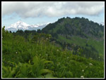
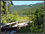
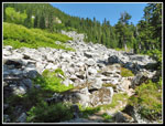
The trail descends and crosses a boulder field. I could now see all the low clouds. They seem to have gone all the way to the Cascade Crest. A little more ups and downs and I arrived at Lake Janus. I took a short break here. It was still only 9:10 am. About 3.5 miles done in 1:24. The bugs were not bad as I took a break. I was afraid they would chase me down the trail but as long as I was moving they were almost unnoticeable. Later in the day they were noticeable when I stopped. Still nowhere near needing to use bug spray. There were some backpackers at the lake. I also passed several backpackers coming out as I hiked in. Back on the way it only took a few minutes until I met a group from the Pacific Crest Trail Association. They were cutting out lots across the trail. They stopped me while they worked to get the cut log off the trail. When it took longer than expected I was able to bushwhack around the log and continue on.
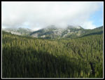
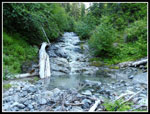
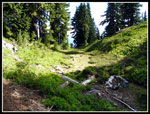
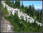
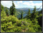
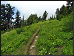
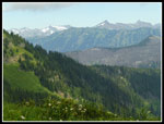
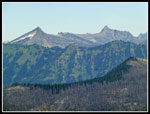
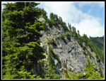
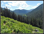
The trail now climbs steadily back to the crest. The PCT is a gently graded trail most everywhere I have hiked it. It makes for fast hiking. The trail switchbacked up the slope to the crest. Just before the top there is a creek below the trail that is running strong. I could hear the rushing water. It was the last water I saw up to Grizzly Peak. On the crest the route changed radically. Thick forest gave way to forest and meadows. Some sections were blasted from rock and had views out. It was mostly clear to the east. The trail crosses several times from the eat to the west side and back. It is mostly below the crest crossing over at saddles. It was still mostly cloudy to the west. I took a few short side trails to campsites. They are dry but several had room for 2-4 tents. The PCT through hikers will be flowing through here soon.
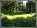
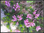
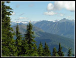
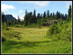
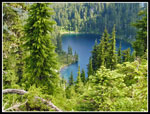
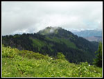
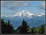
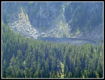
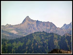
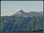
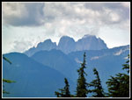
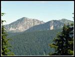
There are a number of meadows that break up the forest sections. Between the meadows and views there is a lot to see. Soon I could look down on Glasses Lake. There is no spot with a completely clear view but I could see most of the lake. The route wound around. The crest goes north but has some sections that turn sharply. The section heading for Grizzly Peak heads to the west. A ways after Glasses Lake I could look down on Heather Lake. It is quite large. In several places I had clear views out to Glacier Peak. The south side still has snow on it. I also picked out Mt. David and Whittier Peak. I have been up David many times. When I saw what I thought was Grizzly Peak (it was) the top was in the clouds. I had expected much clearer skies. The route goes below the top then has long switchbacks up an open slope. This could be a flower bonanza at the right time. I saw a lot of spirea, cow parsnip, bistort, and a few more.
After the switchbacks the route traverses a meadow and crosses within a few feet of the summit of Grizzly Peak I took a short path to the 5597' high point. It is forested with a bare camp spot. I had lunch here but even with a steady breeze the bugs were pretty annoying. I arrived at 11:35 am and only stayed until 12:03 pm. The trail continues along the crest to several more meadowed bumps to the north. It is about 3.5 miles to Pear Lake. I passed one woman coming up who camped at Pear Lake. It would make a nice two day trip.
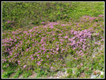
Starting down I immediately noticed Saucer Lake across the valley. There were several meadows high up that were covered in purple heather. The best color of the trip. Though the trail dropped about 1450' to Lake Janus there were a lot more uphill sections than I remembered being downhills on the way up. The ups and down were never very long but they added up over eight miles of trail. The high ridge walking was my favorite part of the trip. I was disappointed when I left the ridge and dropped into forest. Soon after I met the PCTA work party again. They had removed several big logs. Back at Lake Janus I stopped for another break. I planned to stay awhile but the bugs were annoying enough to keep it short. After 12.5 miles of hiking I still had 3.5 miles to go. The 700' climb back to Union Gap was not my favorite part though the gentle grading helped. On the last few miles I met a number of groups heading up.
One final descent and I was back at the trailhead. A look at the road from above showed many cars parking along it. Many dozens. I was back at my car at 4:10 pm. Thanks to the early start I hiked 16 miles and was still back pretty early. This was a great trip. Since I tweaked my knee a month ago I have been staying on smoother trails. The PCT really fit the bill. There was great variety with a lake, a summit, great views, dark forest, and green meadows. The distance is a good leg stretcher but eh smooth trail makes it seem shorter. There is only 1700' from the start to the high point. There are also a number of ups and downs. I guesstimated that the total gain was about 3600'. It took a long time for me to hike this route but it will not be my last time. It was a great day out in the mountains.
Click on thumbnails to get
larger pictures.
Trips - 2016
Home
I had been to this point on the four winter trips. I had gone up on both sides of Smith Brook. The real trail is right of the brook. Right about where we went up on several winter trips. It is a little brushy at the start and the brush was still wet. Though the lot had 8-10 cars in it I guess that I was the first person going up this day. There were no more brushy spots the rest of the day. The trail gains about 700' from 4000' to 4680 at Union Gap in roughly 1.3 miles. The forest service website says it is .9 miles to Union Gap. The hand drawn map at the trailhead says 1.5 miles. No two books agree. My GPS says about 1.3. The trail used to start above where the road switchbacks. Now it starts right out of the lot and can also be reached from the road switchback.
I headed out at a good pace as the route switchbacks uphill. Before long I reached the Henry Jackson Wilderness sign. The trail is well graded as it climbs the slope. I reached the Pacific Crest Trail (PCT) at Union Gap. The winter route starts out the same but stays farther left as it heads for Mt. McCausland. A left turn at the gap heads south on the PCT. Many folks go this way to Lake Valhalla. Much shorter than hiking in from Stevens Pass. Right heads north to Lake Janus and Grizzly Peak. The two lakes are a great draw for day hikers and backpackers. I headed right and began to descend. The gap and most of the trail to Lake Janus and beyond is in forest. I did not see many wildflowers though those I did see were ones I have been seeing most every week this summer. Some queen's cup, bunchberry, several patches of columbine, and one lone tiger lily. I have seen that flower for what seems like a dozen weeks in a row.
The trail descends and crosses a boulder field. I could now see all the low clouds. They seem to have gone all the way to the Cascade Crest. A little more ups and downs and I arrived at Lake Janus. I took a short break here. It was still only 9:10 am. About 3.5 miles done in 1:24. The bugs were not bad as I took a break. I was afraid they would chase me down the trail but as long as I was moving they were almost unnoticeable. Later in the day they were noticeable when I stopped. Still nowhere near needing to use bug spray. There were some backpackers at the lake. I also passed several backpackers coming out as I hiked in. Back on the way it only took a few minutes until I met a group from the Pacific Crest Trail Association. They were cutting out lots across the trail. They stopped me while they worked to get the cut log off the trail. When it took longer than expected I was able to bushwhack around the log and continue on.
The trail now climbs steadily back to the crest. The PCT is a gently graded trail most everywhere I have hiked it. It makes for fast hiking. The trail switchbacked up the slope to the crest. Just before the top there is a creek below the trail that is running strong. I could hear the rushing water. It was the last water I saw up to Grizzly Peak. On the crest the route changed radically. Thick forest gave way to forest and meadows. Some sections were blasted from rock and had views out. It was mostly clear to the east. The trail crosses several times from the eat to the west side and back. It is mostly below the crest crossing over at saddles. It was still mostly cloudy to the west. I took a few short side trails to campsites. They are dry but several had room for 2-4 tents. The PCT through hikers will be flowing through here soon.
There are a number of meadows that break up the forest sections. Between the meadows and views there is a lot to see. Soon I could look down on Glasses Lake. There is no spot with a completely clear view but I could see most of the lake. The route wound around. The crest goes north but has some sections that turn sharply. The section heading for Grizzly Peak heads to the west. A ways after Glasses Lake I could look down on Heather Lake. It is quite large. In several places I had clear views out to Glacier Peak. The south side still has snow on it. I also picked out Mt. David and Whittier Peak. I have been up David many times. When I saw what I thought was Grizzly Peak (it was) the top was in the clouds. I had expected much clearer skies. The route goes below the top then has long switchbacks up an open slope. This could be a flower bonanza at the right time. I saw a lot of spirea, cow parsnip, bistort, and a few more.
After the switchbacks the route traverses a meadow and crosses within a few feet of the summit of Grizzly Peak I took a short path to the 5597' high point. It is forested with a bare camp spot. I had lunch here but even with a steady breeze the bugs were pretty annoying. I arrived at 11:35 am and only stayed until 12:03 pm. The trail continues along the crest to several more meadowed bumps to the north. It is about 3.5 miles to Pear Lake. I passed one woman coming up who camped at Pear Lake. It would make a nice two day trip.
Starting down I immediately noticed Saucer Lake across the valley. There were several meadows high up that were covered in purple heather. The best color of the trip. Though the trail dropped about 1450' to Lake Janus there were a lot more uphill sections than I remembered being downhills on the way up. The ups and down were never very long but they added up over eight miles of trail. The high ridge walking was my favorite part of the trip. I was disappointed when I left the ridge and dropped into forest. Soon after I met the PCTA work party again. They had removed several big logs. Back at Lake Janus I stopped for another break. I planned to stay awhile but the bugs were annoying enough to keep it short. After 12.5 miles of hiking I still had 3.5 miles to go. The 700' climb back to Union Gap was not my favorite part though the gentle grading helped. On the last few miles I met a number of groups heading up.
One final descent and I was back at the trailhead. A look at the road from above showed many cars parking along it. Many dozens. I was back at my car at 4:10 pm. Thanks to the early start I hiked 16 miles and was still back pretty early. This was a great trip. Since I tweaked my knee a month ago I have been staying on smoother trails. The PCT really fit the bill. There was great variety with a lake, a summit, great views, dark forest, and green meadows. The distance is a good leg stretcher but eh smooth trail makes it seem shorter. There is only 1700' from the start to the high point. There are also a number of ups and downs. I guesstimated that the total gain was about 3600'. It took a long time for me to hike this route but it will not be my last time. It was a great day out in the mountains.
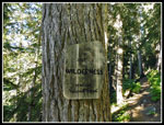 Wilderness Boundary |
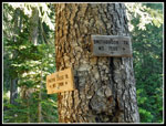 Union Gap |
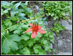 Columbine |
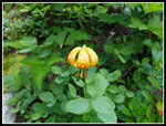 Tiger Lily |
 Cloudy To The West |
 Queen's Cups |
 Slabby Creek |
 Bright Grass |
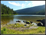 Lake Janus |
 Lupine |
 Ridge Top |
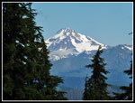 Glacier Peak In Sight |
 Meadows Near Crest |
 Blooming Heather |
 Open Trail |
 View Northeast |
 Bigger Meadow |
 Even Bigger Meadow |
 Glasses Lake |
 Heather Lake |
 Heather Meadow |
 Spirea Below Grizzly Peak |
 Clouds Over Ridge |
 Nearing The Summit |
 Grizzly Summit |
 Glacier From Grizzly |
 Saucer Lake |
 Clear Sky |
 Bump & Glacier Peak |
 Mt. David |
 Whittier Peak |
 Whittier & David |
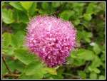 Spirea Close Up |
 Grizzly Slope |
 Peaks To The West |
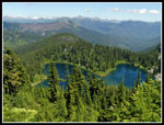 Glasses Lake Again |
 Wide Open Trail |
 Labyrinth Mountain |
 Lake Janus Again |
 Ascending To Union Gap |
 Boulder Field |
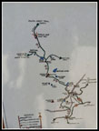 Trailhead Map |
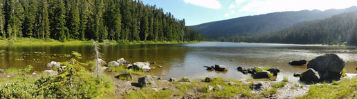 Here is a morning panorama shot of Lake Janus |
Trips - 2016
Home