4-25-10
Gary
came up
with an unusual idea for a spring snow scramble. It was also John's
birthday. After a number of questions he convinced me to give it a
shot. Gary hiked up the Middle Shaser Trail back in 1977. It wasn't
until we were on the trail that he mentioned there were a few spots
they lost the route back then. This is not a maintained trail and we
had no idea what to expect 33 years after Gary's trip. That's what
makes for an adventure.
The goal was Miller Peak though conditions would have to be very good to make it that far on an abandoned trail followed by a long snowshoe approach. We met at Eastgate on I-90 at 7:20 am and headed east. It was cloudy as we crossed Snoqualmie Pass and dropped down to Cle Elum. We took Highway 970 then 97 over Blewett Pass the dropped down to the north end of the Old Blewett Pass Highway. Up that road then a right turn to the trailhead where the North and Middle Forks of Shaser Creek meet.
Gary and I had biked up the gated NF Shaser Road on a misguided attempt to reach the Three Brothers. We ended up dropping the bikes at the pass and scrambling Miller Peak. The road is too long for a day hike on snow so the abandoned trail along the ridge separating the North and Middle Forks of Shaser Creek would be our route. One reason the trail was abandoned was because of extensive logging. That added one more unknown to the conditions.
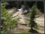
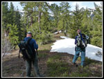
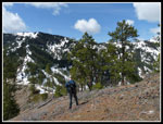
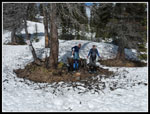
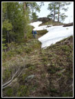
We arrived and were ready to go by 9:20. A faint trail was visible above the road bank cut and up we went. A minute later we reached... an outhouse. A frame wrapped in plastic not a real trailhead building. No more trail. So much for finding it at the beginning and following it all the way. We bushwhacked ahead and up the ridge.
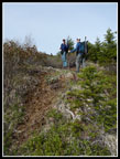
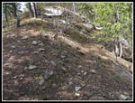
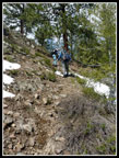
There are fir trees and underbrush on the lower part. It is also steepest for the first 700' or so. On the positive side there is only one ridge to follow as it does not split. Up we went with ice axes getting caught on all the low branches. There was a little snow on the road just before we parked but none on the ridge for quite a ways up. At times we saw what might have been old tread though it was very indistinct. For the most part we were either on the crest or just to the south side.
After nearly 1000' of gain we reached a road that cut across the ridge. It wrapped around the north side and appeared to be easier walking than staying on the crest. It was...at first. Soon snow appeared. Not nice consolidated snow. This was more like quicksand. Sink to your knees quicksand. After far too long on the snow we chose to climb up the steep bank and back to the ridge. Bushwhacking up there was easier than the snowy road. The soft snow did cause some concern about making it all the way to Miller.
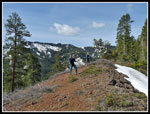
We met the road again where it crossed over the ridge. Instead of heading steeply up the ridge we took the road to the left a ways. Gary went up first and John and I went farther to a side ridge before heading up. We met up and continued up to the ridge top. After the first 1000' of gain the ridge became gentler. We found bits and pieces of the old trail. usually it was just to the right of the ridge. Unfortunately that side held snow where the crest was mostly snow free. We stayed mostly on the crest.
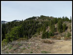
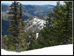
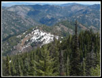
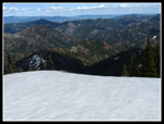
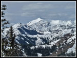
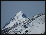
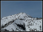
At times we had nice views out. The road up to near Iron Mountain was highlighted by snow on the bare hillside. Miller Peak came into view and looked to be a long way away still. We stopped at one high point to check maps and GPS and could see much of the rest of the ridge. It does have ups and downs though none are very long.
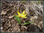
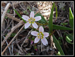
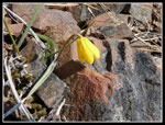
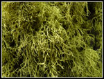
Flowers are beginning along the ridge. We saw a lot of glacier lilies as well as spring beauty, ball head waterleaf, yellow bells, as well as the "leaves" of bitterroot. There will be a lot of pink in the rocky higher sections of the ridge in a month or so. There were a number of short rocky sections to scramble over though none proved to be a problem.
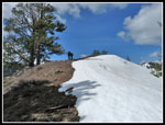
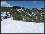
At long last we reached a nice viewpoint to see the pass where the NF Shaser Road reaches the ridge leading to Miller. Rather than continue up our ridge where it turned narrow and rocky we could see easy access to the road heading to the pass. We dropped down to where a spur reached the ridge and were then on continuous snow.
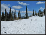
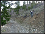
On went the snowshoes and the spur soon brought us to the NF Shaser Road. The road was firm in places and soft enough to post hole in snowshoes in others. Definitely not as consolidated as we had hoped for. The road makes long gentle switchbacks which is not great for speed but the soft thin snow on steep slopes was not looking good either. We stayed on the road most of the way. On the last long switchback left we could see the road above us and hacked our way up a bare steep slope to rejoin the road and cut out a fairly long section. From there it was a gentle walk over to the saddle.
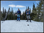
I have been to this point many times but never with this much snow. We found a bare spot under some trees and sat down for a food break and to decide where to go next. It was now 1:15. Still early but we had taken nearly 4 hours to bushwhack up the ridge and trudge through the soft snow. Miller was still two miles away with another 1300' of gain. On the other hand we needed to climb only 400' up the other side of the saddle to reach Point 5510, also known as Jester Mountain, That was sounding pretty good.
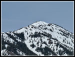
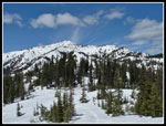
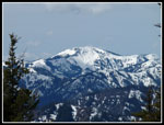
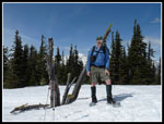
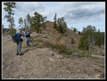
This is a motorcycle trail and the first part up from the saddle is a steep vertical rut up the slope. It was actually a little nicer buried under feet of snow. Where the summer trail turns right to contour around the peak we stayed on the ridge and continued up. It did not take long to reach the top. There are multiple summits and a flat area at the top. The top of Mt. Rainier was in the clouds but Miller, Mt. Stuart, Navaho, Little Navaho, Earl, and Jolly Mountain were visible from the summit or nearby. The Middle Shaser ridge we climbed continues to near the summit of Jester and we could look down on our route.
The sun was out and the wind was light. I would have liked to spend a few hours on top. Unfortunately, we had taken a long time to get up and it would take quite a while to get down. After less than half and hour it was time to go. Dropping back to the pass was fast and easy. then came the slog on the even softer snow on the road. At least gravity was on our side now. Back at the short cut spot we were not too enthusiastic about descending the thin soft and steep snow. A little lower we found a better spot and dropped back down to the road.
When we reached the road we were all ready to get rid of the snowshoes. Bushwhacking along the ridge was a bit faster on the descent but still took a lot of time. This time we planned to stay on the ridge and avoid the snowy road section. We continued down and down and finally came out on the road... exactly where we climbed the bank on the way up. We once again slogged through the soft snow up to our knees. Oh well...
We met exactly the zero people we expected to see on this trip. I was glad to finally see the car again. It was nearly 5:30 at the finish making for an eight hour day on the trail or abandoned trail as the case may be. It was a fun day. We might not have reached Miller but Jester was a fine substitute. My first of many Teanaway peaks this coming year. Thanks to Gary for coming up with the idea and to John for spending his birthday bushwhacking up a long abandoned trail. To top off the day Twin Pines restaurant near Cle Elum was actually open at 6:20 when we arrived. Of course, they did close at 6:30 so as not to have to deal with all those hungry folks heading home from the weekend. For the day we hiked about 10 miles with 3400' of elevation gain.
Click on thumbnails to get
larger pictures.
Trips - 2010
Home
The goal was Miller Peak though conditions would have to be very good to make it that far on an abandoned trail followed by a long snowshoe approach. We met at Eastgate on I-90 at 7:20 am and headed east. It was cloudy as we crossed Snoqualmie Pass and dropped down to Cle Elum. We took Highway 970 then 97 over Blewett Pass the dropped down to the north end of the Old Blewett Pass Highway. Up that road then a right turn to the trailhead where the North and Middle Forks of Shaser Creek meet.
Gary and I had biked up the gated NF Shaser Road on a misguided attempt to reach the Three Brothers. We ended up dropping the bikes at the pass and scrambling Miller Peak. The road is too long for a day hike on snow so the abandoned trail along the ridge separating the North and Middle Forks of Shaser Creek would be our route. One reason the trail was abandoned was because of extensive logging. That added one more unknown to the conditions.
We arrived and were ready to go by 9:20. A faint trail was visible above the road bank cut and up we went. A minute later we reached... an outhouse. A frame wrapped in plastic not a real trailhead building. No more trail. So much for finding it at the beginning and following it all the way. We bushwhacked ahead and up the ridge.
There are fir trees and underbrush on the lower part. It is also steepest for the first 700' or so. On the positive side there is only one ridge to follow as it does not split. Up we went with ice axes getting caught on all the low branches. There was a little snow on the road just before we parked but none on the ridge for quite a ways up. At times we saw what might have been old tread though it was very indistinct. For the most part we were either on the crest or just to the south side.
After nearly 1000' of gain we reached a road that cut across the ridge. It wrapped around the north side and appeared to be easier walking than staying on the crest. It was...at first. Soon snow appeared. Not nice consolidated snow. This was more like quicksand. Sink to your knees quicksand. After far too long on the snow we chose to climb up the steep bank and back to the ridge. Bushwhacking up there was easier than the snowy road. The soft snow did cause some concern about making it all the way to Miller.
We met the road again where it crossed over the ridge. Instead of heading steeply up the ridge we took the road to the left a ways. Gary went up first and John and I went farther to a side ridge before heading up. We met up and continued up to the ridge top. After the first 1000' of gain the ridge became gentler. We found bits and pieces of the old trail. usually it was just to the right of the ridge. Unfortunately that side held snow where the crest was mostly snow free. We stayed mostly on the crest.
At times we had nice views out. The road up to near Iron Mountain was highlighted by snow on the bare hillside. Miller Peak came into view and looked to be a long way away still. We stopped at one high point to check maps and GPS and could see much of the rest of the ridge. It does have ups and downs though none are very long.
Flowers are beginning along the ridge. We saw a lot of glacier lilies as well as spring beauty, ball head waterleaf, yellow bells, as well as the "leaves" of bitterroot. There will be a lot of pink in the rocky higher sections of the ridge in a month or so. There were a number of short rocky sections to scramble over though none proved to be a problem.
At long last we reached a nice viewpoint to see the pass where the NF Shaser Road reaches the ridge leading to Miller. Rather than continue up our ridge where it turned narrow and rocky we could see easy access to the road heading to the pass. We dropped down to where a spur reached the ridge and were then on continuous snow.
On went the snowshoes and the spur soon brought us to the NF Shaser Road. The road was firm in places and soft enough to post hole in snowshoes in others. Definitely not as consolidated as we had hoped for. The road makes long gentle switchbacks which is not great for speed but the soft thin snow on steep slopes was not looking good either. We stayed on the road most of the way. On the last long switchback left we could see the road above us and hacked our way up a bare steep slope to rejoin the road and cut out a fairly long section. From there it was a gentle walk over to the saddle.
I have been to this point many times but never with this much snow. We found a bare spot under some trees and sat down for a food break and to decide where to go next. It was now 1:15. Still early but we had taken nearly 4 hours to bushwhack up the ridge and trudge through the soft snow. Miller was still two miles away with another 1300' of gain. On the other hand we needed to climb only 400' up the other side of the saddle to reach Point 5510, also known as Jester Mountain, That was sounding pretty good.
This is a motorcycle trail and the first part up from the saddle is a steep vertical rut up the slope. It was actually a little nicer buried under feet of snow. Where the summer trail turns right to contour around the peak we stayed on the ridge and continued up. It did not take long to reach the top. There are multiple summits and a flat area at the top. The top of Mt. Rainier was in the clouds but Miller, Mt. Stuart, Navaho, Little Navaho, Earl, and Jolly Mountain were visible from the summit or nearby. The Middle Shaser ridge we climbed continues to near the summit of Jester and we could look down on our route.
The sun was out and the wind was light. I would have liked to spend a few hours on top. Unfortunately, we had taken a long time to get up and it would take quite a while to get down. After less than half and hour it was time to go. Dropping back to the pass was fast and easy. then came the slog on the even softer snow on the road. At least gravity was on our side now. Back at the short cut spot we were not too enthusiastic about descending the thin soft and steep snow. A little lower we found a better spot and dropped back down to the road.
When we reached the road we were all ready to get rid of the snowshoes. Bushwhacking along the ridge was a bit faster on the descent but still took a lot of time. This time we planned to stay on the ridge and avoid the snowy road section. We continued down and down and finally came out on the road... exactly where we climbed the bank on the way up. We once again slogged through the soft snow up to our knees. Oh well...
We met exactly the zero people we expected to see on this trip. I was glad to finally see the car again. It was nearly 5:30 at the finish making for an eight hour day on the trail or abandoned trail as the case may be. It was a fun day. We might not have reached Miller but Jester was a fine substitute. My first of many Teanaway peaks this coming year. Thanks to Gary for coming up with the idea and to John for spending his birthday bushwhacking up a long abandoned trail. To top off the day Twin Pines restaurant near Cle Elum was actually open at 6:20 when we arrived. Of course, they did close at 6:30 so as not to have to deal with all those hungry folks heading home from the weekend. For the day we hiked about 10 miles with 3400' of elevation gain.
 Getting Started |
 Onto The Ridge Top |
 More Of The Ridge |
 Glacier Lily |
 Spring Beauties |
 Miller Over Another Peak |
 The Old Trail! |
 Open Crest |
 John & Gary |
 Dropped Below Ridge |
 Snow On Right Side |
 Yellow Bell |
 Nearing Saddle |
 Leaving The Ridge |
 Ridge Below |
 County Line Saddle |
 Bare Lunch Spot |
 View Of Ridge Up |
 Miller Peak |
 Jester Summit |
 . .Good Look At Ridge |
 Rounded Peak |
 Me On Jester |
 Navaho Peak |
 Mt. Stuart |
 Miller Close Up |
 Back On The Ridge |
 Very Green Moss |
 Descending Ridge |
 Cut Bank Descent |
Trips - 2010
Home