7/4-7/13
At
the last minute I signed on to a
four day backpacking trip with Janet and Gwen to Horseshoe Basin in the
Pasayten Wilderness. We would end up right on the Canadian border. This
would be my third trip to Horseshoe Basin. The previous trips in 2007
and 2009
were also over the July 4th Holiday weekend. I still want to visit in
October for the larch trees. Early summer is a great time as there is
plenty of water and copious wildflowers. Any time of year there are
peaks at or above 8000' to hike up. Now on to the report.
Day One
Gwen worked the evening before so our meeting time of 8:00 am was late for me but very early for her. From Mill Creek we headed out Highway 2 to Wenatchee then north on Highway 97 nearly to the Canadian border. We turned off at Tonasket heading to Loomis then onto the Toats Coulee Road. The road took us from the 89 degree valley at Tonasket (elevation 950') to the Iron Gate trailhead (elevation 6150') where it was a much more comfortable 64 degrees. The road is paved to the Iron Gate turn off. That last 5.8 miles is rocky but in reasonably good shape. Gwen's Subaru had no problems. There was a mini-van at the trailhead.
We arrived at 2:50 pm. Taking out several stops it was just over six hours of driving. I was surprised to find only 11 other cars and one horse trailer in the lot. It is a long drive but with Thursday being a holiday I expected more folks taking advantage of a four day weekend. A hiker we talked with in the basin came in on Friday and said there were even a few less cards in the lot then. We saw other hikers but had a great deal of solitude the whole time. We were packed up and on the trail at 3:10 pm. Since my last visit a brand new wooden trailhead map has been added. It shows trails and mileage. A nice addition.
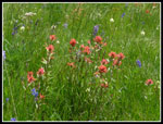
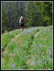
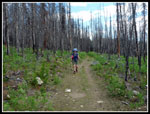
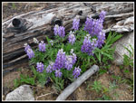
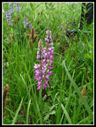
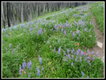
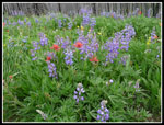
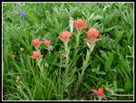
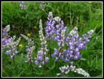
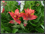
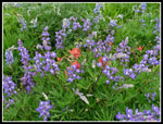
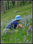
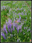
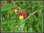
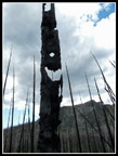
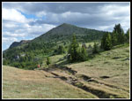
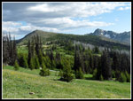
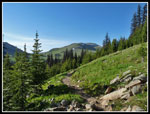
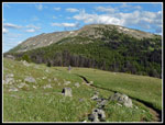
The route for the first 4 1/2 miles to Sunny Pass follows an old road. It begins a gentle descent from Iron Gate. The drop is less than 200'. Recent rains left more water and mud than I have seen on the route. Still, it was not a problem. The really wet spots are few and far between. Forest quickly gives way to the big 2006 burn and it continues almost to Sunny Pass. Underbrush, small trees and wildflowers have dramatically changed the sooty black scene we had on my first visit one year after the fire. There is a meadow near the start and another one nearing the end of the burn that were awash in colorful flowers. Indian paintbrush, lupine, asters, shooting stars, and much much more. We even saw some white shooting stars. The flowers through there are right near their peak.
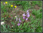
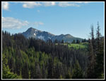
All the flower photos slowed us way down. It was 6:05 pm when we arrived at 7200' Sunny Pass. We had 4.5 miles down and about 2.3 miles to go to Louden Lake. Great views of Horseshoe Basin from the pass. Very little snow to be seen. We picked up our pace but the flower show did not abate. Lots more shooting stars, western anemone, and marsh marigolds plus more of those seen earlier. From Horseshoe Pass it was less than a mile to go. As we hiked around the basin the wind began to pick up. When we reached our intended camping spot it was blowing harder. Our friend David mentioned heading to the basin and he ended up camping in our vicinity.
It was past 7:00 pm when we set up camp and fixed dinner. As we crawled into our tents the wind was blowing even harder. Probably 12 to 15 mph most all night long. It was a very cold wind. It had been 89 degrees down below in Tonasket but about 40 with a stiff wind chill at night. I might not have brought a tarp tent if I thought it would be that cold. With a down jacket the night was fine for me. It was a long day with the drive and hike. We were all beat.
Click on thumbnails to get
larger pictures.
Report Day 2
Trips - 2013
Home
Day One
Gwen worked the evening before so our meeting time of 8:00 am was late for me but very early for her. From Mill Creek we headed out Highway 2 to Wenatchee then north on Highway 97 nearly to the Canadian border. We turned off at Tonasket heading to Loomis then onto the Toats Coulee Road. The road took us from the 89 degree valley at Tonasket (elevation 950') to the Iron Gate trailhead (elevation 6150') where it was a much more comfortable 64 degrees. The road is paved to the Iron Gate turn off. That last 5.8 miles is rocky but in reasonably good shape. Gwen's Subaru had no problems. There was a mini-van at the trailhead.
We arrived at 2:50 pm. Taking out several stops it was just over six hours of driving. I was surprised to find only 11 other cars and one horse trailer in the lot. It is a long drive but with Thursday being a holiday I expected more folks taking advantage of a four day weekend. A hiker we talked with in the basin came in on Friday and said there were even a few less cards in the lot then. We saw other hikers but had a great deal of solitude the whole time. We were packed up and on the trail at 3:10 pm. Since my last visit a brand new wooden trailhead map has been added. It shows trails and mileage. A nice addition.
The route for the first 4 1/2 miles to Sunny Pass follows an old road. It begins a gentle descent from Iron Gate. The drop is less than 200'. Recent rains left more water and mud than I have seen on the route. Still, it was not a problem. The really wet spots are few and far between. Forest quickly gives way to the big 2006 burn and it continues almost to Sunny Pass. Underbrush, small trees and wildflowers have dramatically changed the sooty black scene we had on my first visit one year after the fire. There is a meadow near the start and another one nearing the end of the burn that were awash in colorful flowers. Indian paintbrush, lupine, asters, shooting stars, and much much more. We even saw some white shooting stars. The flowers through there are right near their peak.
All the flower photos slowed us way down. It was 6:05 pm when we arrived at 7200' Sunny Pass. We had 4.5 miles down and about 2.3 miles to go to Louden Lake. Great views of Horseshoe Basin from the pass. Very little snow to be seen. We picked up our pace but the flower show did not abate. Lots more shooting stars, western anemone, and marsh marigolds plus more of those seen earlier. From Horseshoe Pass it was less than a mile to go. As we hiked around the basin the wind began to pick up. When we reached our intended camping spot it was blowing harder. Our friend David mentioned heading to the basin and he ended up camping in our vicinity.
It was past 7:00 pm when we set up camp and fixed dinner. As we crawled into our tents the wind was blowing even harder. Probably 12 to 15 mph most all night long. It was a very cold wind. It had been 89 degrees down below in Tonasket but about 40 with a stiff wind chill at night. I might not have brought a tarp tent if I thought it would be that cold. With a down jacket the night was fine for me. It was a long day with the drive and hike. We were all beat.
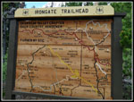 New Trailhead Map |
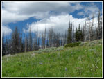 Puffy Clouds |
 First Wildflowers |
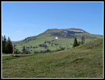
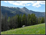 Windy Peak |
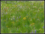 Many Varieties |
 Indian Paintbrush |
 Janet On Road/Trail |
 Into The Burn |
 Lupine Patch |
 Colorful Lupine |
 Second Meadow |
 Paintbrush & Lupine |
 Clump Of Paintbrush |
 Multi Colored Lupine |
 Twin Paintbrush |
 Bouquet |
 Gwen At Work |
 Great Colors |
 Shooting Stars |
 Columbine |
 Smiling Face? |
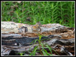 Chipmunk |
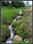 Cascading Creek |
 View Back From Pass |
 Armstrong Mountain |
 Pick Peak |
 Pick & Windy |
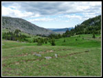
 Trail Through Basin |
 Forest & Windy Peak |
 Nearing Camp |
Report Day 2
Trips - 2013
Home