8/08-11/14
Back
in 2005
Gary and I hiked a loop up Buck Creek, to Image Lake, To Lyman Lakes,
and down through Spider Meadows. The Suiattle River Road had washed out
at Downey Creek two years prior. With the last two miles of road not
drivable we expected the usual crowds to be less. We were right. There
were only two other groups at the lake. The road then washed out nine
miles farther down and the traffic remained minimal. Getting there
required a longer hike and a much longer drive. The Suiattle Road is
set to reopen late this October and we wanted to get in one more trip
before it happened. John was also very interested in doing the loop.
With that in mind, we scheduled four days for the trip.
Day 1
We met at my home in North Seattle at 5:30 am. Early morning traffic was light and we had an easy drive to Highway 2 and east over Stevens Pass. The one possible problem with the trip was the large number of fires we have had on the east side of the Cascades this summer. One fire was burning about six miles east of our trailhead. A short cooling trend was ending too bringing high temperatures back to the area. Not good for fires and not good to hike in. The wind had been blowing the smoke away but a change could give us days of haze and choking smoke. Still, we had the time allotted and decided to go. It took about 3 hours to reach the end of the road at the Phelps Creek trailhead. The unpaved section of the Chiwawa River Road was in very good shape. The Spur to the trailhead in less good shape. My sedan had no trouble at a very slow pace though it is very rocky.
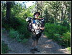
There were already quite a few cars in the small lot. This loop has two trailheads separated by about 3 miles and 700' of elevation. Our plan was to park at the higher Phelps Creek end and drive the car down to the lower trailhead at Trinity. One of us (John) would then have to walk the tree miles up to Phelps Creek hoping to hitch a ride with an arriving party. At the road junction we saw plenty of room to park. That saved John .60 miles of hiking the road. At 8:54 am Gary and I headed up the trail with Johns backpack. A few minutes earlier he drove down to leave the car at the junction. I doubted we could carry our own backpacks on our backs and carry his pack in the front for long. I was wrong. With four-day backpacks in the 25 to 28 lb. range it was not that hard. Gary and I each carried John's pack for five minutes then handed off to the other. The strangest part was the two groups we passed who did not seen to see anything strange about front and back backpacks. Oh well... The trail grade is gentle and we made good time.
We stopped for a break after crossing Leroy Creek. A group of teenagers were there and they did comment on our third pack. We reached the creek at 10:20 am. That was 3.4 miles down the trail in 1:26. Almost 2.4 mph is not bad while carrying a loaded backpack and wearing one. John did us one better. He drove down the road, parked, and hiked up 2.3 miles gaining 700' then hiked the 3.4 miles of trail and caught up with us at Leroy Creek. The result is instead of waiting for him in the parking lot we were well on our way by 10:20 am.
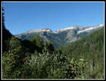
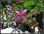
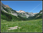
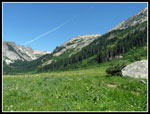
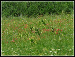
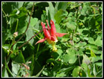
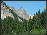
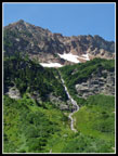
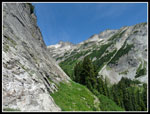
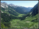
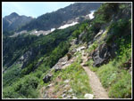
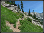
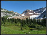
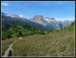
The Phelps Creek trail takes over five miles to reach Spider Meadow. First on an old road then trail, it is not steep though it does gain about 1200'. We stopped at the beginning of the meadow. Green as far as you can see. Steep walls on all sides of the basin. Waterfalls seen on both sides. It really is a very pretty place. Deserving of the heavy visitation it receives. The wildflower display was passed the peak but there was still a good show to be seen. Some Indian paintbrush and lupine, lots of asters, thistles, and more. The day was warming fast as we hiked across the long meadow. Lots of flowers to photograph as we made slow progress.
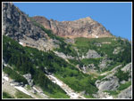
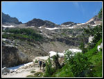
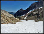
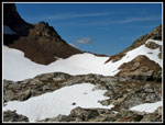
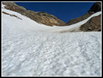
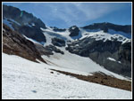
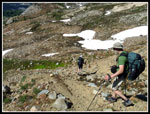
At the end of the valley the gently graded trail becomes decidedly more vertical. At the junction with the trail to Phelps Basin we stopped for lunch. It was getting darn right hot. Gary spotted a dear which would be far from the last one we would see. The trail up to Larch Knob is narrow as it switchbacks up the steep headwall of the valley. It avoids cliffs and finds a way to continue climbing. Sweat was pouring off me when we reached the campsites. We dropped to the largely snow covered creek to pump water. With a cool breeze blowing over the snow it went from hot to cold in just a few minutes. Not that I as complaining. Great views of Spider Meadow below us and the Spider Glacier was just above.
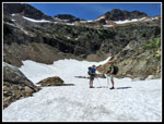
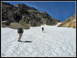
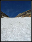
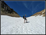
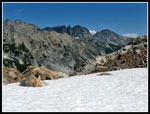
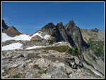
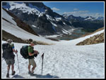
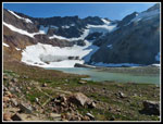
When Gary and I came down the glacier in 2005 we found a hollowed out and dangerous route. We had to skirt the ice on the rocky edge. This time it was night and day different. The glacier/snowfield was solid snow. This was the first time I had backpacked with light low top trail shoes. The snow travel would be the crux of the trip. I brought light Yaktrax but no ice axe or even microspikes. The snow was firm with a little softness on top. Just fine for good traction. There is a route up the ridge on the right but the snow was very easy to climb on this warm day. If icy it would have been a different story. We slogged up to the top to find several other groups. We headed back a ways on the bare dirt and rock ridge for more views. There was some haze to the east but it was pretty clear. After another food break we headed for Spider Gap. There was very little wind on the way up but a very hard and cold wind at the gap. After some photos we headed down hoping to get out of the wind.
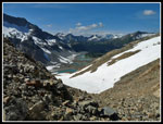
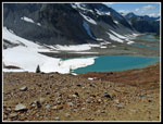
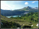
In 2005 much of the way up the north side of the gap was on loose rock. this time it was mostly on snow. Much easier. We made good time coming down. The views of peaks to the north were soon joined by Upper Lyman Lake and the Lyman Glacier. It is a pretty amazing place. Once off snow the ridge narrowed and dropped steeply. We chose to head back a bit to where we could drop to our right on easier terrain. A short steep part gave way to easier scrambling. It took awhile to drop all the way to the upper lake. We lost most of the wind coming down but it was blowing at the lake. Last time we were pressed for time and went right by the lake. This time we took another break near the shore. I thought there were a number of camps at the upper lake and on the way down to the lower lake. That's not what we found.
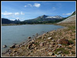
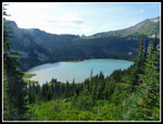
The trail to the lower Lyman Lake is longer than I thought. It has a number of ups and downs as it traverses green meadows and drops to forest. Great views along most of it. We found one real camp with a tent. That was it. It was 5:55 pm when we finally crossed the outlet to Lyman Lake. We turned left on a trail heading up the lake looking for a campsite large enough for our three tents. A short trail brought us to a big spot with one tent. Crap. We kept looking and found nothing along the trail. Finally we headed back off to the right and found a good spot. Turns out there were half a dozen more spots back in there. We were beat when we finally set up camp. Later in the evening we walked over to the lake shore for photos. The nearly full "super moon" was reddish in the clear sky. We did not head for out tents until dark just after 9:00 pm. For the day Gary and I hiked 11.2 miles with 4100' of gain. John added another 2.3 miles with 700' on his road walk.
Below the photos for day 1 is a link to day 2. There are four total pages, one for each day, with a written report and photos for each.
Click on thumbnails to get
larger pictures.
Day 2
Trips - 2014
Home
Day 1
We met at my home in North Seattle at 5:30 am. Early morning traffic was light and we had an easy drive to Highway 2 and east over Stevens Pass. The one possible problem with the trip was the large number of fires we have had on the east side of the Cascades this summer. One fire was burning about six miles east of our trailhead. A short cooling trend was ending too bringing high temperatures back to the area. Not good for fires and not good to hike in. The wind had been blowing the smoke away but a change could give us days of haze and choking smoke. Still, we had the time allotted and decided to go. It took about 3 hours to reach the end of the road at the Phelps Creek trailhead. The unpaved section of the Chiwawa River Road was in very good shape. The Spur to the trailhead in less good shape. My sedan had no trouble at a very slow pace though it is very rocky.
There were already quite a few cars in the small lot. This loop has two trailheads separated by about 3 miles and 700' of elevation. Our plan was to park at the higher Phelps Creek end and drive the car down to the lower trailhead at Trinity. One of us (John) would then have to walk the tree miles up to Phelps Creek hoping to hitch a ride with an arriving party. At the road junction we saw plenty of room to park. That saved John .60 miles of hiking the road. At 8:54 am Gary and I headed up the trail with Johns backpack. A few minutes earlier he drove down to leave the car at the junction. I doubted we could carry our own backpacks on our backs and carry his pack in the front for long. I was wrong. With four-day backpacks in the 25 to 28 lb. range it was not that hard. Gary and I each carried John's pack for five minutes then handed off to the other. The strangest part was the two groups we passed who did not seen to see anything strange about front and back backpacks. Oh well... The trail grade is gentle and we made good time.
We stopped for a break after crossing Leroy Creek. A group of teenagers were there and they did comment on our third pack. We reached the creek at 10:20 am. That was 3.4 miles down the trail in 1:26. Almost 2.4 mph is not bad while carrying a loaded backpack and wearing one. John did us one better. He drove down the road, parked, and hiked up 2.3 miles gaining 700' then hiked the 3.4 miles of trail and caught up with us at Leroy Creek. The result is instead of waiting for him in the parking lot we were well on our way by 10:20 am.
The Phelps Creek trail takes over five miles to reach Spider Meadow. First on an old road then trail, it is not steep though it does gain about 1200'. We stopped at the beginning of the meadow. Green as far as you can see. Steep walls on all sides of the basin. Waterfalls seen on both sides. It really is a very pretty place. Deserving of the heavy visitation it receives. The wildflower display was passed the peak but there was still a good show to be seen. Some Indian paintbrush and lupine, lots of asters, thistles, and more. The day was warming fast as we hiked across the long meadow. Lots of flowers to photograph as we made slow progress.
At the end of the valley the gently graded trail becomes decidedly more vertical. At the junction with the trail to Phelps Basin we stopped for lunch. It was getting darn right hot. Gary spotted a dear which would be far from the last one we would see. The trail up to Larch Knob is narrow as it switchbacks up the steep headwall of the valley. It avoids cliffs and finds a way to continue climbing. Sweat was pouring off me when we reached the campsites. We dropped to the largely snow covered creek to pump water. With a cool breeze blowing over the snow it went from hot to cold in just a few minutes. Not that I as complaining. Great views of Spider Meadow below us and the Spider Glacier was just above.
When Gary and I came down the glacier in 2005 we found a hollowed out and dangerous route. We had to skirt the ice on the rocky edge. This time it was night and day different. The glacier/snowfield was solid snow. This was the first time I had backpacked with light low top trail shoes. The snow travel would be the crux of the trip. I brought light Yaktrax but no ice axe or even microspikes. The snow was firm with a little softness on top. Just fine for good traction. There is a route up the ridge on the right but the snow was very easy to climb on this warm day. If icy it would have been a different story. We slogged up to the top to find several other groups. We headed back a ways on the bare dirt and rock ridge for more views. There was some haze to the east but it was pretty clear. After another food break we headed for Spider Gap. There was very little wind on the way up but a very hard and cold wind at the gap. After some photos we headed down hoping to get out of the wind.
In 2005 much of the way up the north side of the gap was on loose rock. this time it was mostly on snow. Much easier. We made good time coming down. The views of peaks to the north were soon joined by Upper Lyman Lake and the Lyman Glacier. It is a pretty amazing place. Once off snow the ridge narrowed and dropped steeply. We chose to head back a bit to where we could drop to our right on easier terrain. A short steep part gave way to easier scrambling. It took awhile to drop all the way to the upper lake. We lost most of the wind coming down but it was blowing at the lake. Last time we were pressed for time and went right by the lake. This time we took another break near the shore. I thought there were a number of camps at the upper lake and on the way down to the lower lake. That's not what we found.
The trail to the lower Lyman Lake is longer than I thought. It has a number of ups and downs as it traverses green meadows and drops to forest. Great views along most of it. We found one real camp with a tent. That was it. It was 5:55 pm when we finally crossed the outlet to Lyman Lake. We turned left on a trail heading up the lake looking for a campsite large enough for our three tents. A short trail brought us to a big spot with one tent. Crap. We kept looking and found nothing along the trail. Finally we headed back off to the right and found a good spot. Turns out there were half a dozen more spots back in there. We were beat when we finally set up camp. Later in the evening we walked over to the lake shore for photos. The nearly full "super moon" was reddish in the clear sky. We did not head for out tents until dark just after 9:00 pm. For the day Gary and I hiked 11.2 miles with 4100' of gain. John added another 2.3 miles with 700' on his road walk.
Below the photos for day 1 is a link to day 2. There are four total pages, one for each day, with a written report and photos for each.
 Parking Lot View |
 Dual Backpacks |
 Red Willowherb |
 Spider Meadow |
 Right Side Of Meadow |
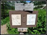 Campsite Signs |
 Indian Paintbrush |
 High Basin Walls |
 Columbine |
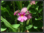 Pink Monkey Flower |
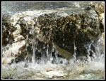 Micro Falls |
 Granite Spire |
 Big Waterfall |
 View To Phelps Basin |
 Spider Meadow Below |
 Climbing Headwall |
 Gary & John On Trail |
 Time To Pump Water |
 On The Snow |
 Heading Up Glacier |
 Looking Down Glacier |
 A Little Behind |
 Gary On Glacier |
 7 Fingered Jack & Maude |
 Near Spider Gap |
 Gap Is Just Ahead |
 North Side Of Gap |
 Descending On Snow |
 Looking Up To Gap |
 Lyman Glacier |
 Ice On Upper Lake |
 Descending On Dirt |
 Looking Down Lake |
 Looking Up Lake |
 Upper Lake & Gap |
 Bonanza Peak |
 Meadows & Lake |
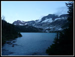
 Lyman Lake |
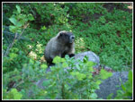 First Marmot Of Trip |
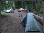 Lyman Camp |
 Lake At Dusk |
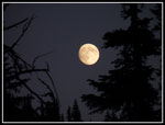 Super Moon |
Day 2
Trips - 2014
Home