5-30-16
For
the last day of a holiday
weekend I chose a short drive and a long hike. I did not want to fight
the traffic crossing a mountain pass. A good choice. With construction
work, the backup east from Cle Elum reached 30 miles. I was out the
door at 7:15 am heading south through Seattle. I took Highway
169 southwest from Renton to the Kent-Kangley Road. A left
turn and I followed it all the way to the wall of hills rising from the
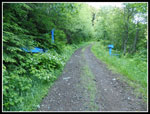
plateau. The gated road starts right by 346 Ave SE. I was the first car
to arrive at 8:10 am. I was soon on my way. After a damp few days the
sky was blue with a forecast high of 70 degrees. Just about perfect. On
my first
visit in 2011 the road had just
been decommissioned. All the
culverts had been removed and there were numerous steep drops and
equally steep climbs to get by. It was tiresome. On my second
visit in
2014 it was better. The road was much more trail like and the dips were
more rounded. Much has changed the past two years.
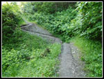
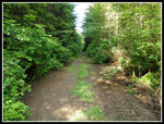
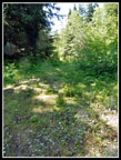
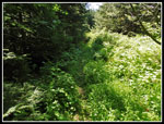
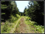
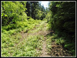
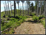
Now the deeper dips have trails cut across the slope to make it much easier to hike down and up. The trail has narrowed more. Soon it will need brushing to allow easy passage in places. All in all, it is much better than in 2011. My first visit was on a very cold late January day. Clouds were low and I had views up but not down from higher viewpoints. On my second visit in mid April it was cloudy in the morning but cleared up somewhat. This time it was a little hazy but there were no clouds at all. The many dips along the trial end after about .5 to .75 miles. The narrow trial/road reaches a spot where it was graded from the opposite direction. Now it is plenty wide once again.
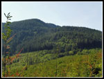
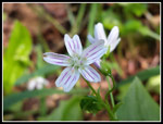
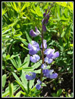
The wildflower show was much better than I expected. Down low I saw thousands of buttercups and some foxglove in bloom. A few skunk cabbage were easily smelled though there were no yellow blooms. Many white thimbleberry flowers line the route. Salmonberries ranged form pale yellow to very red and ripe. I even found several patches of bright yellow scotch broom. I followed the graded road/trail looking for a left turn I recalled up ahead. What I found was a "Y" with both options about the same size. It did not look like a recalled the turn. After a little thought I chose the left route. It turned out to be correct. The road/trail wound around and I soon reached the clear cut I remembered well. In 2011 the cut was very fresh. Lots of slag piles and no green on the ground. Now there are many new trees, some up to 5 - 10 feet tall.
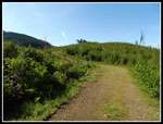
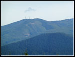
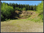
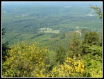
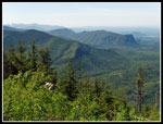
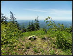
The open cut provides a view that is seldom seen. Looking to the north I could see the south side of Rattlesnake Ledge. Most of the land between the ledge and McDonald Mountain is in the Tacoma Watershed and off limits. I could see Squak, Tiger, and Rattlesnake Mountains. In the background were Si, Teneriffe, and Green Mountain. At the end of the clear cut I met the main road to the towers. A left turn and in minute or two a junction. Left goes downhill. Right goes right to a logging landing. Middle begins to climb up the mountain. Choose the middle road. I passed another gate. Closed on my first visit. Open on the second and now third visits. The road makes one switchback and climbs up towards the tower. I could see the tower at first from the clear cut. It looked far away and very high. The road is not really steep but it climbs at a consistent grade. I finally reached the last junction. There is a big old gravel pit there. Straight ahead the road quickly reaches a gate warning staying out of the watershed. To the right is another gate. That is the correct choice.
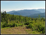
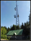
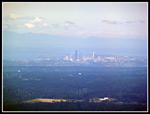
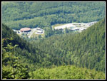
The road continues climbing until at last it reaches the tower complex. There is a pretty good view to the west from here. I could bring in Seattle with maximum zoom. The Olympic Mountains would have really stood out if not for the haze. It was about 10:05 am when I arrived. I was a little disappointed that it was hazy already. To this point I had traveled 4.2 miles with 2300' of elevation gain. The real summit of McDonald Mountain is 2.25 trail miles south along the ridge. It is only a little higher. Even so, with all the ups and downs it adds another 1300' of elevation gain. To the tower is an easy hike with pretty good views. To the real summit is a much harder trip at 13 miles with 3600' of gain. Of course I was going on to the summit once again. So far I had not seen a single person. I had a nice break and did not head on until 10:25 am.
A short drop down the road from the tower and an obvious old road heads off south. It is covered with grass with a couple boot tracks that have pounded down the grass. A short way along this route the flower show really picked up. First were huge patches of spring beauty. Then came more buttercups and some orange Indian paintbrush. In 2011 the ridge top road was still very much an old road. In just five years it has become a trail. All the damp grass soaked my boots and socks but they dried out as the day warmed up. I noticed a path off to the west side that I had not seen on the earlier trips. It just dropped a short way to a viewpoint. Now i could see south to Mt. Rainier. This is the first spot that has a look at Mt. Rainier.
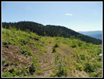
The route climbs a little and then descends. Along here there once was a fire lookout. It has been logged since then and I have not found any old debris showing exactly where it was located. Columbine joined the flower show. I saw a whole lot of it from there to the summit. All of it near its peak. The route makes a short climb to a spot that was lined with small trees just inches apart on my first visit. Then I pried my way through the green wall to find an obvious trail on the other side. Now the trees are gone and the route just enters forest. A very short walk leads to the big clear cut. This one too was fresh in 2011. I had to fight through slash and logs, going over small hills to get across the the road on the far side. It was much easier in 2014. It is a snap now. The trail leaves the forest and makes a level traverse through grass. it needs a few more feet or it will be lost. I quickly reached the end of an old logging spur. This now winds through the cut and peters out just before reaching the road. Far easier than on my fist two visits.
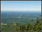
The road across the clear cut has excellent views out to the west and south. Mt. Rainier is front and center. Once on the next old road I turned right and uphill. The road gains a bit then flattens out. After awhile it begins to drop, steeply in places. it quickly loses 250'. It ends at a junction. Turn right and begin to climb. Regain that 250' and 150' more. It flattens for a minute then begins to climb again. When it almost reaches the ridge top an overgrown spur goes off right and uphill. This is just a couple minutes from the top. Keep going until near the very top. The summit is forested. After climbing over several logs and going around a patch of slide alder I reached the viewpoint. Some decent views out but not nearly as good as from the big clear cut. The reason to continue on to the summit is to say you have reached it and/or to extend the hike to significant distance and elevation gain. It is five miles round trip longer than Mt. Si with 200' more elevation gain.
I had a short stay on the summit. With plenty of photo stops plus the stay at the tower site I took 3:20 to reach the summit. It was still only 11:38 am. My stay lasted 35 minutes. The trip back was much quicker. The steep 250' climb was not much appreciated. Back at the clear cut I was photographing columbine when I noticed a bench above the road cut. I missed seeing it on the way in. It is solidly nailed together. Quite a view on a clear day. I continued back along the ridge and just before leaving the old grassy road near the tower site I sighted the first people of the day. A couple were heading to the clear cut. I had had total solitude for over five hours and 8.75 miles. One more stop at the tower viewpoint and I continued down. The rest of the way down I met two solo hikers bringing the total to four hikers seen all day. Not too bad. Add in the two hikers seen on the Downey Creek Trail on Saturday and my Memorial Day Weekend total was six hikers seen. Who says all the trails are packed?
McDonald Mountain is not a wilderness experience. Much of the way is on old or still used road. It is not a trip I would do in mid summer when the high mountain country is snow free. It is a heck of a workout with a good deal of solitude, good views, and an unexpectedly good spring wildflower display. It will remain a trip I do every two to four years.
Click on thumbnails to get
larger pictures.
Trips - 2016
Home
Now the deeper dips have trails cut across the slope to make it much easier to hike down and up. The trail has narrowed more. Soon it will need brushing to allow easy passage in places. All in all, it is much better than in 2011. My first visit was on a very cold late January day. Clouds were low and I had views up but not down from higher viewpoints. On my second visit in mid April it was cloudy in the morning but cleared up somewhat. This time it was a little hazy but there were no clouds at all. The many dips along the trial end after about .5 to .75 miles. The narrow trial/road reaches a spot where it was graded from the opposite direction. Now it is plenty wide once again.
The wildflower show was much better than I expected. Down low I saw thousands of buttercups and some foxglove in bloom. A few skunk cabbage were easily smelled though there were no yellow blooms. Many white thimbleberry flowers line the route. Salmonberries ranged form pale yellow to very red and ripe. I even found several patches of bright yellow scotch broom. I followed the graded road/trail looking for a left turn I recalled up ahead. What I found was a "Y" with both options about the same size. It did not look like a recalled the turn. After a little thought I chose the left route. It turned out to be correct. The road/trail wound around and I soon reached the clear cut I remembered well. In 2011 the cut was very fresh. Lots of slag piles and no green on the ground. Now there are many new trees, some up to 5 - 10 feet tall.
The open cut provides a view that is seldom seen. Looking to the north I could see the south side of Rattlesnake Ledge. Most of the land between the ledge and McDonald Mountain is in the Tacoma Watershed and off limits. I could see Squak, Tiger, and Rattlesnake Mountains. In the background were Si, Teneriffe, and Green Mountain. At the end of the clear cut I met the main road to the towers. A left turn and in minute or two a junction. Left goes downhill. Right goes right to a logging landing. Middle begins to climb up the mountain. Choose the middle road. I passed another gate. Closed on my first visit. Open on the second and now third visits. The road makes one switchback and climbs up towards the tower. I could see the tower at first from the clear cut. It looked far away and very high. The road is not really steep but it climbs at a consistent grade. I finally reached the last junction. There is a big old gravel pit there. Straight ahead the road quickly reaches a gate warning staying out of the watershed. To the right is another gate. That is the correct choice.
The road continues climbing until at last it reaches the tower complex. There is a pretty good view to the west from here. I could bring in Seattle with maximum zoom. The Olympic Mountains would have really stood out if not for the haze. It was about 10:05 am when I arrived. I was a little disappointed that it was hazy already. To this point I had traveled 4.2 miles with 2300' of elevation gain. The real summit of McDonald Mountain is 2.25 trail miles south along the ridge. It is only a little higher. Even so, with all the ups and downs it adds another 1300' of elevation gain. To the tower is an easy hike with pretty good views. To the real summit is a much harder trip at 13 miles with 3600' of gain. Of course I was going on to the summit once again. So far I had not seen a single person. I had a nice break and did not head on until 10:25 am.
A short drop down the road from the tower and an obvious old road heads off south. It is covered with grass with a couple boot tracks that have pounded down the grass. A short way along this route the flower show really picked up. First were huge patches of spring beauty. Then came more buttercups and some orange Indian paintbrush. In 2011 the ridge top road was still very much an old road. In just five years it has become a trail. All the damp grass soaked my boots and socks but they dried out as the day warmed up. I noticed a path off to the west side that I had not seen on the earlier trips. It just dropped a short way to a viewpoint. Now i could see south to Mt. Rainier. This is the first spot that has a look at Mt. Rainier.
The route climbs a little and then descends. Along here there once was a fire lookout. It has been logged since then and I have not found any old debris showing exactly where it was located. Columbine joined the flower show. I saw a whole lot of it from there to the summit. All of it near its peak. The route makes a short climb to a spot that was lined with small trees just inches apart on my first visit. Then I pried my way through the green wall to find an obvious trail on the other side. Now the trees are gone and the route just enters forest. A very short walk leads to the big clear cut. This one too was fresh in 2011. I had to fight through slash and logs, going over small hills to get across the the road on the far side. It was much easier in 2014. It is a snap now. The trail leaves the forest and makes a level traverse through grass. it needs a few more feet or it will be lost. I quickly reached the end of an old logging spur. This now winds through the cut and peters out just before reaching the road. Far easier than on my fist two visits.
The road across the clear cut has excellent views out to the west and south. Mt. Rainier is front and center. Once on the next old road I turned right and uphill. The road gains a bit then flattens out. After awhile it begins to drop, steeply in places. it quickly loses 250'. It ends at a junction. Turn right and begin to climb. Regain that 250' and 150' more. It flattens for a minute then begins to climb again. When it almost reaches the ridge top an overgrown spur goes off right and uphill. This is just a couple minutes from the top. Keep going until near the very top. The summit is forested. After climbing over several logs and going around a patch of slide alder I reached the viewpoint. Some decent views out but not nearly as good as from the big clear cut. The reason to continue on to the summit is to say you have reached it and/or to extend the hike to significant distance and elevation gain. It is five miles round trip longer than Mt. Si with 200' more elevation gain.
I had a short stay on the summit. With plenty of photo stops plus the stay at the tower site I took 3:20 to reach the summit. It was still only 11:38 am. My stay lasted 35 minutes. The trip back was much quicker. The steep 250' climb was not much appreciated. Back at the clear cut I was photographing columbine when I noticed a bench above the road cut. I missed seeing it on the way in. It is solidly nailed together. Quite a view on a clear day. I continued back along the ridge and just before leaving the old grassy road near the tower site I sighted the first people of the day. A couple were heading to the clear cut. I had had total solitude for over five hours and 8.75 miles. One more stop at the tower viewpoint and I continued down. The rest of the way down I met two solo hikers bringing the total to four hikers seen all day. Not too bad. Add in the two hikers seen on the Downey Creek Trail on Saturday and my Memorial Day Weekend total was six hikers seen. Who says all the trails are packed?
McDonald Mountain is not a wilderness experience. Much of the way is on old or still used road. It is not a trip I would do in mid summer when the high mountain country is snow free. It is a heck of a workout with a good deal of solitude, good views, and an unexpectedly good spring wildflower display. It will remain a trip I do every two to four years.
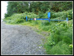 Trailhead Gate |
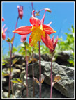
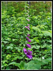 Foxglove |
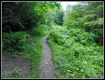 Narrow Trail |
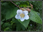 Thimbleberry |
 Trail Across Dip |
 Trail Widens |
 Into The First Clear Cut |
 Rattlesnake Mountain |
 West Rattlesnake |
 Summit Tower |
 Open Gate |
 Gravel Pit |
 False Summit Tower |
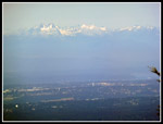 Sea-Tac Airport |
 View West |
 Hazy Morning |
 Old Ridge Road |
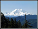 Mt. Rainier |
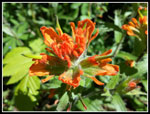 Indian Paintbrush |
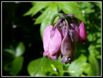 Bleeding Heart |
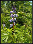 Lupine |
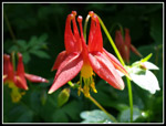 Columbine I |
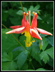 Columbine II |
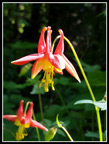 Columbine III |
 Getting Overgrown |
 Forested Bumps |
 Downtown Seattle |
 Big Clear Cut |
 Onto Another Old Road |
 Almost At Summit |
 Summit View |
 Spring Beauty |
 Industry |
 Back At Clear Cut |
 More Lupine |
 Silver Snag |
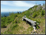 Bench With A View |
 A Last Columbine |
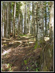 Forest Trail |
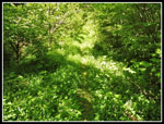 Brushy Old Road/Trail |
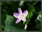 Colorful Spring Beauty |
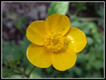 Buttercup |
Trips - 2016
Home