8-29-20
John
was free and we chose to do a
loop trip I have done a number of times but not since 2004. Only one
section is usually crowded with hikers. We hoped for a lot of solitude
on the vast majority of the route. It includes three summits and an off
trail ridge walk. The trails are all open to motorcycles. Usually not a
lot of them. Hoping to beat the crowds up Miller Peak we planned to
meet at 8:15 am at the 3220' Miller Bear Trailhead. Just as I went out
my front door I remembered that my NW Forest Pass had just expired. It
is still unclear if tickets are being written during the pandemic but a
day pass is only $5.00 and the fine is over $100. I chose to go back
in, start up my computer, and print one. By the time I had that done I
was 15 minutes late. I let John know. Traffic was light and I reached
the trailhead at 8:20 am. There were no other cars there. Stafford
Creek Trailhead had a couple open spots down in the lot. What happened
the the crazy summer crowds? We were on the trail at 7:27 am.
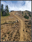
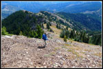
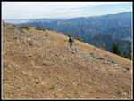
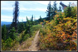
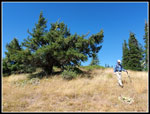
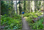
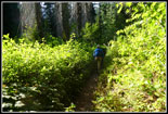
The Miller trail starts pretty flat as it slowly moves up the valley. The several creek crossings were no problem this late in the summer. Most of the 3100' of elevation gain is in the last couple miles. I was surprised to find quite a few ripe huckleberries. Very sweet berries. Other than berry stops we made pretty good time. One big tree has fallen well across the trail. Until branches are cut it will be a very hard crossing for bikes or horses. We went well off trail to get around it. That was the only problem seen all day. When we reached the end of the valley the grade became a lot steeper. From 500' gained per mile it jumps to about 900' per mile. The grade is pretty smooth allowing for a steady pace. This is a motorcycle trail in in places the ground is more like talcum powder. Just walking kicks up a lot of dust. I don't recall it ever being this bad.
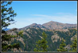
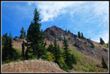
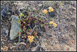
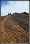
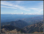
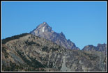
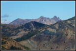
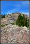
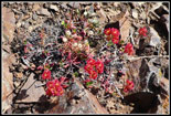
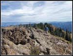
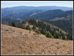
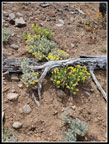
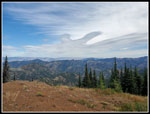
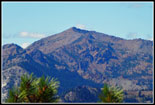
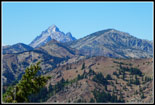
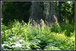
The forest gives way to the first ridge top and views out. We could see Iron Bear Peak right across the valley. We would be there hours later. Wildflowers are about done. We saw a few Indian paintbrush and one small patch of scarlet gilia. Not much more. Some balsamroot have already turned crumbly gray. More climbing and switchbacks brought us to the junction of the Miller summit route and the County Line Trail. The sign is gone and the trail at the junction has really been torn up by wheels. More climbing took us to a view of the summit of Miller. A short steep section leads to the summit ridge. The views just keep getting better. It is not far along the summit ridge to the summit. We arrived at 10:30 am. It took us 2:07 to climb 4.2 miles gaining 3180' to the 6400' summit.
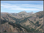
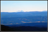
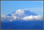
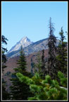
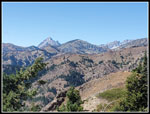
Mt. Stuart had only a small amount of snow on the south side. Most everything else was bare. Mt. Rainier had low clouds but most of the mountain was in the clear. We had a few clouds passing over but the sky was mostly blue. It is usually pretty hot in late August over here but this day it was sunny and warm but not hot. This would be our high point and the best views of the day. We took a nice long break. 52 minutes later at 11:22 am we started down. Going all the way back to the County Line Trail adds a lot of time and distance. We chose to drop off the east ridge and follow it until dropping to the trail farther east. There is some loose rock dropping down but it is not too bad. The ridge has ups and downs with one short scramble spot. Right where we needed to drop to the trail I stopped for sunscreen and to zip off pants legs and switch to a short sleeve shirt. A cool morning had turned into a warm afternoon.
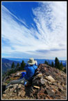
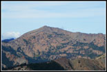
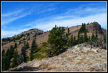
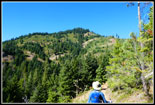
Once back on trail we made better time as we dropped to the low point where an old logging road comes up from Shaser Creek. In 2002 Gary and I tried to bike to Three Brothers and ended up at this junction. Just before the junction A runner passed us going in the opposite direction. That was the first person we saw right near the mid point of our trip. So far solitude was not a problem. The climb out of the saddle is steep and really rocky. Just straight up the fall line. At the top we went into forest. The trail climbs as it rounds Jester Mountain. 100' below the summit we turned off trail and walked up to the high point. Good views east and trees blocking some views. A window in the trees provides a view of Mt. Stuart with Little Navaho right below it. We arrived at 1:08 pm. Just before leaving the trail two more motorcycles went by. The count was up to 3 human sightings in over 4 1/2 hours.
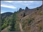
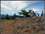
We expected to see folks atop nearby Iron Bear Peak so we took our break on Jester. The wind was picking up but was nowhere near the 11-21 mph with gust to 29 mph. More like gusts to 10 mph. I finished my lunch and took it easy. The summit register was soaking wet. Time for a new one. Oh, I forgot to mention that I saw a register on Miller for the first time in 30 years of visiting. We spent almost an hour on top. At 2:05 we headed on. We dropped to the trail and followed it to the next low spot. Right about there John noticed an animal climbing up a point next to the trail. I did not see it until it was on top and heading over to the other side. It was medium sized with dark fur. A marten? We did not get a good enough view to tell. From the low spot the trail climbs quickly up to the top of Iron Bear Peak.
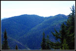
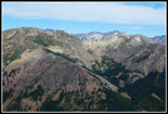
Much to our surprise there was nobody there. We decided on another break. In the short time it took to hike from Jester to Iron Bear Mt. Rainier went from in the clear to completely hidden in clouds. Otherwise, the views were still pretty good. We spent 19 minutes on top leaving at 2:47 pm. From the 5489' summit to the 3180' parking lot was almost all down hill. About 5 miles of downhill. John saw a mountain biker go by from the summit but I did not see him. I was still at 3 sightings. The trail from Iron Bear down to the Iron Creek - Bear Creek - Teanaway Ridge junction is the busiest part of our route. I expected to see multiple groups here. It was not to be. The trail drops with switchbacks as it descends the slope. We reached the junction without seeing anyone. The Bear Creek Trail is not used much. We did see more folks on it than the other 9+ miles of the route. That included a group of three motorcycles and one mountain biker near the end. Forget about switchbacks. The Bear Creek Trail was more of a straight line as it dropped down into the valley.
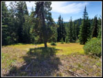
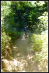
The upper creek crossings were all dry. We were more than half the way down before we saw any water. Farther down we had to rock hop as the creek grew. There are a number of short ups and downs along the creek. Bear Creek provided one more treat. More ripe thimbleberries at first then some ripe huckleberries. Enough in one spot that we stopped to graze. The Teanaway Valley is not known for berries. This was a nice surprise. The last couple miles seemed to go on and on. I was glad to see the bridge at the end of the trail. On my last visit there was no bridge. Just a creek to get across that could be pretty big in late spring. It has made the crossing easy but soaking your feet in the creek at the end of the hike more difficult.
We reached the trailhead at 4:40 pm. With all our summit breaks we took just over 8 hours to hike 13 miles with about 3900' of elevation gain. This trip had it all. Three summits, a ridge walk, shady valleys, ripe berries, great weather, and very few other people. Just what we were looking for, especially in the year of the coronavirus. We never even put on face masks for a change. I have done this trip a number of times in October for the golden larch trees. It was fun to do it in the summer. This was a really fun trip from start to finish.
Click on thumbnails to get
larger pictures.
Trips - 2020
Home
The Miller trail starts pretty flat as it slowly moves up the valley. The several creek crossings were no problem this late in the summer. Most of the 3100' of elevation gain is in the last couple miles. I was surprised to find quite a few ripe huckleberries. Very sweet berries. Other than berry stops we made pretty good time. One big tree has fallen well across the trail. Until branches are cut it will be a very hard crossing for bikes or horses. We went well off trail to get around it. That was the only problem seen all day. When we reached the end of the valley the grade became a lot steeper. From 500' gained per mile it jumps to about 900' per mile. The grade is pretty smooth allowing for a steady pace. This is a motorcycle trail in in places the ground is more like talcum powder. Just walking kicks up a lot of dust. I don't recall it ever being this bad.
The forest gives way to the first ridge top and views out. We could see Iron Bear Peak right across the valley. We would be there hours later. Wildflowers are about done. We saw a few Indian paintbrush and one small patch of scarlet gilia. Not much more. Some balsamroot have already turned crumbly gray. More climbing and switchbacks brought us to the junction of the Miller summit route and the County Line Trail. The sign is gone and the trail at the junction has really been torn up by wheels. More climbing took us to a view of the summit of Miller. A short steep section leads to the summit ridge. The views just keep getting better. It is not far along the summit ridge to the summit. We arrived at 10:30 am. It took us 2:07 to climb 4.2 miles gaining 3180' to the 6400' summit.
Mt. Stuart had only a small amount of snow on the south side. Most everything else was bare. Mt. Rainier had low clouds but most of the mountain was in the clear. We had a few clouds passing over but the sky was mostly blue. It is usually pretty hot in late August over here but this day it was sunny and warm but not hot. This would be our high point and the best views of the day. We took a nice long break. 52 minutes later at 11:22 am we started down. Going all the way back to the County Line Trail adds a lot of time and distance. We chose to drop off the east ridge and follow it until dropping to the trail farther east. There is some loose rock dropping down but it is not too bad. The ridge has ups and downs with one short scramble spot. Right where we needed to drop to the trail I stopped for sunscreen and to zip off pants legs and switch to a short sleeve shirt. A cool morning had turned into a warm afternoon.
Once back on trail we made better time as we dropped to the low point where an old logging road comes up from Shaser Creek. In 2002 Gary and I tried to bike to Three Brothers and ended up at this junction. Just before the junction A runner passed us going in the opposite direction. That was the first person we saw right near the mid point of our trip. So far solitude was not a problem. The climb out of the saddle is steep and really rocky. Just straight up the fall line. At the top we went into forest. The trail climbs as it rounds Jester Mountain. 100' below the summit we turned off trail and walked up to the high point. Good views east and trees blocking some views. A window in the trees provides a view of Mt. Stuart with Little Navaho right below it. We arrived at 1:08 pm. Just before leaving the trail two more motorcycles went by. The count was up to 3 human sightings in over 4 1/2 hours.
We expected to see folks atop nearby Iron Bear Peak so we took our break on Jester. The wind was picking up but was nowhere near the 11-21 mph with gust to 29 mph. More like gusts to 10 mph. I finished my lunch and took it easy. The summit register was soaking wet. Time for a new one. Oh, I forgot to mention that I saw a register on Miller for the first time in 30 years of visiting. We spent almost an hour on top. At 2:05 we headed on. We dropped to the trail and followed it to the next low spot. Right about there John noticed an animal climbing up a point next to the trail. I did not see it until it was on top and heading over to the other side. It was medium sized with dark fur. A marten? We did not get a good enough view to tell. From the low spot the trail climbs quickly up to the top of Iron Bear Peak.
Much to our surprise there was nobody there. We decided on another break. In the short time it took to hike from Jester to Iron Bear Mt. Rainier went from in the clear to completely hidden in clouds. Otherwise, the views were still pretty good. We spent 19 minutes on top leaving at 2:47 pm. From the 5489' summit to the 3180' parking lot was almost all down hill. About 5 miles of downhill. John saw a mountain biker go by from the summit but I did not see him. I was still at 3 sightings. The trail from Iron Bear down to the Iron Creek - Bear Creek - Teanaway Ridge junction is the busiest part of our route. I expected to see multiple groups here. It was not to be. The trail drops with switchbacks as it descends the slope. We reached the junction without seeing anyone. The Bear Creek Trail is not used much. We did see more folks on it than the other 9+ miles of the route. That included a group of three motorcycles and one mountain biker near the end. Forget about switchbacks. The Bear Creek Trail was more of a straight line as it dropped down into the valley.
The upper creek crossings were all dry. We were more than half the way down before we saw any water. Farther down we had to rock hop as the creek grew. There are a number of short ups and downs along the creek. Bear Creek provided one more treat. More ripe thimbleberries at first then some ripe huckleberries. Enough in one spot that we stopped to graze. The Teanaway Valley is not known for berries. This was a nice surprise. The last couple miles seemed to go on and on. I was glad to see the bridge at the end of the trail. On my last visit there was no bridge. Just a creek to get across that could be pretty big in late spring. It has made the crossing easy but soaking your feet in the creek at the end of the hike more difficult.
We reached the trailhead at 4:40 pm. With all our summit breaks we took just over 8 hours to hike 13 miles with about 3900' of elevation gain. This trip had it all. Three summits, a ridge walk, shady valleys, ripe berries, great weather, and very few other people. Just what we were looking for, especially in the year of the coronavirus. We never even put on face masks for a change. I have done this trip a number of times in October for the golden larch trees. It was fun to do it in the summer. This was a really fun trip from start to finish.
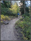 John On The Trail |
 First Views |
 On The Ridge |
 Jester & Iron Bear |
 Wildflowers |
 Climbing To The Summit |
 Near The Top |
 Miller Summit Views |
 Distant Mt. Rainier |
 Neat Clouds |
 Mt. Adams |
 Close Up Mt. Rainier |
 Mt. Stuart Over Navaho |
 Earl Peak |
 Three Brothers |
 Fortune & Ingalls |
 Heading Down |
 Looking Back |
 Bright Color |
 John On The Ridge |
 Traversing Open Slope |
 Time To Descend |
 Miller Summit |
 Trail Is Below Ridge |
 Leaf Colors |
 Jester Colors |
 Narrow Stuart View |
 John On Jester |
 Cloud Formations |
 Wide Tree |
 Bright Meadow |
 Teanaway Peaks |
 Earl Peak Again |
 Stuart & Navaho Again |
 Below Iron Bear |
 Dusty Trail |
 Back In Forest |
 Sunshine |
 Fireweed |
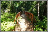 Bridge At The End |
Trips - 2020
Home